 Filter: Categories of Wisconsin Historical Images
Filter: FORMAT_TYPE of prints, photomechanical
Filter: Subject of lakes
Filter: Subject of waterfalls
Filter: Categories of Wisconsin Historical Images
Filter: FORMAT_TYPE of prints, photomechanical
Filter: Subject of lakes
Filter: Subject of waterfalls

| Date: | 1941 |
|---|---|
| Description: | A tourist map of Marinette County, Wisconsin that includes indexes of the lakes and rivers in the county which also identify the fish present, a list of ra... |

| Date: | |
|---|---|
| Description: | A map of the western Upper Peninsula of Michigan and Wisconsin north of Lake Winnebago and east of Lake Pepin and the mouth of the Saint Louis River on Lak... |
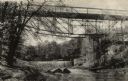
| Date: | 1910 |
|---|---|
| Description: | View from shoreline looking up at the bridge, and the dam. There is a building at the base on the bridge on the opposite shoreline on the right, and anothe... |
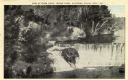
| Date: | 1920 |
|---|---|
| Description: | Elevated view from shoreline of Glen Loch in Irvine Park. Caption reads: "Dam at Glen Loch, Irvine Park, Chippewa Falls, Wis." |

| Date: | 1755 |
|---|---|
| Description: | Map of the Great Lakes region during the French and Indian War. It shows in great detail the territories, borders and boundary lines, Native American tribe... |

| Date: | |
|---|---|
| Description: | Printed color postcard. In the center is a map of Wisconsin with towns, rivers and other attractions over a yellow background. Around the outside is a doub... |
If you didn't find the material you searched for, our Library Reference Staff can help.
Call our reference desk at 608-264-6535 or email us at: