Visit our other Wisconsin Historical Society websites!
 Filter: Categories of Wisconsin Historical Images
Filter: FORMAT_TYPE of prints, photomechanical
Filter: Subject of lakes
Filter: Categories of Wisconsin Historical Images
Filter: FORMAT_TYPE of prints, photomechanical
Filter: Subject of lakes
| Date: | |
|---|---|
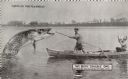
| Description: | Two men, wearing straw hats and overalls, stand in a canoe while attempting to reel in a giant fish. The sun is setting on the horizon in the background. T... |

| Date: | |
|---|---|
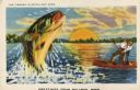
| Description: | A man waves his hat in the air as he rides the giant fish he just caught, using the pole as a reign. The card's caption reads: "Here's the fish I promised ... |
| Date: | 1910 |
|---|---|
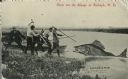
| Description: | A group of men on a lakeshore grapple with a giant pike. Two men pull on a rope hooked to the pike while two more stand ready with harpoon-like sticks. Ano... |
| Date: | 1910 |
|---|---|
| Description: | Photomontage of two men in a rowboat, one of whom is attempting to spear a giant fish with a forked spear, while the other is drinking out of a jug labeled... |

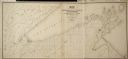
| Date: | 1852 |
|---|---|
| Description: | Map reads: "The State of Wisconsin- compiled from the latest authorities". In addition, there is a scale which is six miles for every inch, and a profile o... |

| Date: | |
|---|---|
| Description: | Map reads: "The United States from the Latest Authorities". View of the states and territories. |

| Date: | 1855 |
|---|---|
| Description: | Map reads "Our Country" which is accompanied by a sailor with a flag to the left and workers rejoicing under the Constitution and Laws to the right. Across... |

| Date: | 1854 |
|---|---|
| Description: | Map reads, "Map of Wisconsin". The map includes the counties, an inset of the city of Milwaukee, total population of each county and of the state. The scal... |

| Date: | |
|---|---|
| Description: | Map reads: "Historic and Scenic Wisconsin — Land of Gathering Waters." In an inset there is a hand-painted depiction of the Wisconsin State Seal. For some ... |

| Date: | 1842 |
|---|---|
| Description: | Map reads: "Wisconsin". The map depicts the counties as of 1842 and the various areas of Indian settlements. The scale is twenty miles for every inch. |

| Date: | 1864 |
|---|---|
| Description: | Map reads: "Johnson's Wisconsin and Michigan". There is a decorative border, a scale of which ten miles is approximately one inch and individual counties d... |
| Date: | |
|---|---|
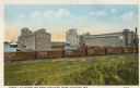
| Description: | Cargill Elevators and Great Northern Yards. Caption reads: "Cargill Elevators and Great Northern Yards, Superior, Wis." |

| Date: | 1861 |
|---|---|
| Description: | A map of Wisconsin showing cities, counties, major roads, railroads, and bodies of water. Includes an inset of the vicinity of Milwaukee. |

| Date: | 1849 |
|---|---|
| Description: | Geological map of the mineral region around Lake Superior, including portions of Michigan, Wisconsin, Iowa and Illinois. |

| Date: | 1858 |
|---|---|
| Description: | Map of the Lake Superior region showing the railroad and steamboat connections. |
| Date: | 1856 |
|---|---|
| Description: | Map of a portion of Douglas and La Pointe counties situated on Lake Superior. |

| Date: | 1857 |
|---|---|
| Description: | A color-coded map of the Lake Superior region, including portions of Wisconsin, Minnesota and Michigan. |
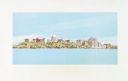
| Date: | 12 11 1970 |
|---|---|
| Description: | Caption on back reads, "Given by 1st National Bank to student customers, 11-XII-70 [12/11/70]. This is the design of their new 'Madisonian' checks." Depi... |

| Date: | 1873 |
|---|---|
| Description: | Portion of Winnebago County map showing Lake Winneconne and the Wolf River. |
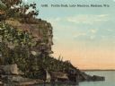
| Date: | |
|---|---|
| Description: | View of Profile Rock at Farwell Point on Lake Mendota. Caption reads: "Profile Rock, Lake Mendota, Madison, Wis." |
If you didn't find the material you searched for, our Library Reference Staff can help.
Call our reference desk at 608-264-6535 or email us at: