Visit our other Wisconsin Historical Society websites!
 Filter: Categories of Wisconsin Historical Images
Filter: FORMAT_TYPE of prints, photomechanical
Filter: Subject of lakes
Filter: Categories of Wisconsin Historical Images
Filter: FORMAT_TYPE of prints, photomechanical
Filter: Subject of lakes
| Date: | |
|---|---|
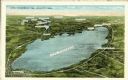
| Description: | Aerial view of Lake Winnebago and vicinity, including Oshkosh, Fond du Lac, Neenah and Appleton. |

| Date: | 1857 |
|---|---|
| Description: | Quarter section of a map of the city of Fond du Lac featuring an illustration of the Lewis House. |

| Date: | 1908 |
|---|---|
| Description: | View towards people standing on the shoreline near a boat landing at Yosts Park. A man and a dog are standing on the pier, and a group of people are in a b... |
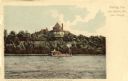
| Date: | 1890 |
|---|---|
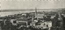
| Description: | The First Baptist Church, pictured in the lower center area of the photograph, organized in 1847 and erected in 1854. St. Raphael's Cathedral in the backgr... |
| Date: | |
|---|---|
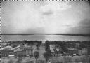
| Description: | Elevated view of Madison featuring Monona Avenue (Martin Luther King, Jr. Boulevard as of January 19, 1987) and Lake Monona. |

| Date: | 1906 |
|---|---|
| Description: | View of Lake Mendota Drive at the foot of Stevens Hill. |
| Date: | 1914 |
|---|---|
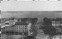
| Description: | Monona Avenue with Lake Monona in the background. (Martin Luther King, Jr. Boulevard as of January 19, 1987). View from the dome of the Wisconsin State Cap... |
| Date: | 1893 |
|---|---|
| Description: | The Ceylon Building from the water, from the Columbian Exposition in Chicago. The building was later purchased by J.J. Mitchell and converted to a private ... |
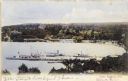
| Date: | 1905 |
|---|---|
| Description: | Elevated view of Lake Geneva Bay, with assorted homes and hotels, and boats docked at long piers. Caption reads: "Geneva Bay, Lake Geneva, Wis." |
| Date: | 1915 |
|---|---|
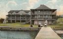
| Description: | The summer home of J.J. Mitchell, formally known as Ceylon Court. Caption at right reads: "Greetings from Lake Geneva, Wis. (near Chicago)", and below read... |

| Date: | 1920 |
|---|---|
| Description: | A map of Madison and the vicinity. Red lines show the street railway. |

| Date: | 1904 |
|---|---|
| Description: | This map shows a plat of the east part of the city, numbered blocks and lots, some landownership, local streets, roads, railroads, wards by number, parks, ... |
| Date: | |
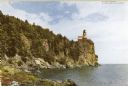
|---|---|
| Description: | View along rocky shoreline toward the lighthouse. Caption reads: "Split Rock Lighthouse on north shore of Lake Superior." |

| Date: | 1844 |
|---|---|
| Description: | Map of Wisconsin including Lakes Michigan and Superior. Inset includes "N.W. Part of Wiskonsan." |

| Date: | 1910 |
|---|---|
| Description: | Aerial view of some of the 26 lakes known collectively as the Chain O' Lakes. Caption reads: "Aeroplane View of Chain O'Lakes, Waupaca, Wis." |
| Date: | 1910 |
|---|---|
| Description: | View from pier towards the Old Mission in La Pointe on Madeline Island. Men are sitting at the shoreline. Caption reads: "Apostle Islands, Wis. Madeline Is... |

| Date: | 1941 |
|---|---|
| Description: | Official highway map of Wisconsin, "the playground of the Midwest," showing the state transportation network prior to World War II. |
| Date: | 1900 |
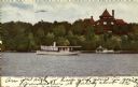
|---|---|
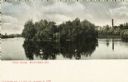
| Description: | View across water towards Tivoli Island. There is a smokestack and a building among trees in the distance. Caption reads: "Tivoli Island, Watertown, Wis." |
If you didn't find the material you searched for, our Library Reference Staff can help.
Call our reference desk at 608-264-6535 or email us at:

