 Filter: Categories of Wisconsin Historical Images
Filter: FORMAT_TYPE of prints, photomechanical
Filter: Subject of land companies
Filter: Subject of dwellings
Filter: Categories of Wisconsin Historical Images
Filter: FORMAT_TYPE of prints, photomechanical
Filter: Subject of land companies
Filter: Subject of dwellings
| Date: | |
|---|---|
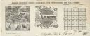
| Description: | Letterhead of Baldwin & Killen Lands and W.H. Killen & Company, dealers of farm, lumber, and mineral lands, from Appleton, Wisconsin, with an image on the ... |

| Date: | 1903 |
|---|---|
| Description: | This map of Richland County, Wisconsin, shows land ownership and acreages, the township and range grid, sections, cities, towns and post offices, roads, ra... |

| Date: | 1910 |
|---|---|
| Description: | Shows land for sale by Rusk Farm Co. in Rusk and Chippewa Counties, as well as farmhouses, roads, and railroads. |

| Date: | 1912 |
|---|---|
| Description: | This map shows land for sale by the Rusk Farm Company. Caption reads, "Look carefully at the map. Notice the thickly settled country on all sides of our la... |

| Date: | 1910 |
|---|---|
| Description: | A land ownership map of the township of Leroy. |
If you didn't find the material you searched for, our Library Reference Staff can help.
Call our reference desk at 608-264-6535 or email us at: