 Filter: Categories of Wisconsin Historical Images
Filter: FORMAT_TYPE of prints, photomechanical
Filter: Subject of land use, rural
Filter: Subject of church buildings
Filter: Categories of Wisconsin Historical Images
Filter: FORMAT_TYPE of prints, photomechanical
Filter: Subject of land use, rural
Filter: Subject of church buildings
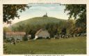
| Date: | 1920 |
|---|---|
| Description: | View of Holy Hill, with a field and the Hillside Hotel in the foreground. Captions read: "America's Favorite Place of Pilgrimage" and "The Holy Hill and Hi... |

| Date: | 1930 |
|---|---|
| Description: | Holiday card with the image of a bell. Inside is a scene of a lake with a cottage on the shore. There is a boat on the lake and a church on the opposite sh... |

| Date: | 1943 |
|---|---|
| Description: | A map that shows the lands for sale by the Tomahawk Land Company of Tomahawk, Wisconsin, in the counties of Langlade, Lincoln, Oneida, and Price. The map s... |

| Date: | 1870 |
|---|---|
| Description: | A map of Iowa County, Wisconsin mounted on cloth that shows the villages of Avoca, Mifflin, Linden, Arena, Helena Station, Highland, Dodgeville, as well as... |

| Date: | 1900 |
|---|---|
| Description: | This set of maps contains four sheets: "Landownership in the Vicinity of Military Reserve and Fort Howard," "Houses Along the River Road to Green Bay," "Ow... |
If you didn't find the material you searched for, our Library Reference Staff can help.
Call our reference desk at 608-264-6535 or email us at: