 Filter: Categories of Wisconsin Historical Images
Filter: FORMAT_TYPE of prints, photomechanical
Filter: Subject of land use, rural
Filter: Subject of railroads
Filter: Categories of Wisconsin Historical Images
Filter: FORMAT_TYPE of prints, photomechanical
Filter: Subject of land use, rural
Filter: Subject of railroads

| Date: | 1913 |
|---|---|
| Description: | Shows lands in green owned and for sale by Homeseekers Land Company, H.J. McKusick, Secretary. Map, part colored. No scale. Photographs on reverse of origi... |
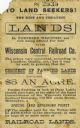
| Date: | |
|---|---|
| Description: | Advertising card for Wisconsin Central Railroad land for sale at $5 an acre. |

| Date: | 1930 |
|---|---|
| Description: | An original color lithograph promoting the Union Pacific Railway Streamliner, and the "City of Denver." In the artist's depiction, a yellow Union Pacific p... |

| Date: | 1943 |
|---|---|
| Description: | A map that shows the lands for sale by the Tomahawk Land Company of Tomahawk, Wisconsin, in the counties of Langlade, Lincoln, Oneida, and Price. The map s... |

| Date: | 1864 |
|---|---|
| Description: | A hand-colored survey map of southeastern Minnesota and Wisconsin, showing the locations of railroads, land grant railroads, land offices, and the 6 and 15... |

| Date: | 1870 |
|---|---|
| Description: | A map of Iowa County, Wisconsin mounted on cloth that shows the villages of Avoca, Mifflin, Linden, Arena, Helena Station, Highland, Dodgeville, as well as... |

| Date: | 1900 |
|---|---|
| Description: | This 1900 map of Walworth County, Wisconsin, shows the township and range grid, towns, sections, landownership and acreages, rural residences, cities and v... |

| Date: | 1909 |
|---|---|
| Description: | This is one of a set of two topographical maps showing land use, roads, railroads, bridges, and buildings with ownership in parts of LaFayette, Greenfield,... |

| Date: | 1930 |
|---|---|
| Description: | This map shows communities, state roads, county roads, railroads, lakes and rivers in the county. Areas marked in red are lands tax deeded to the county. |

| Date: | 1909 |
|---|---|
| Description: | This the second of a set of two topographical maps showing land use, roads, railroads, bridges, and buildings with ownership in parts of LaFayette, Greenfi... |

| Date: | 1924 |
|---|---|
| Description: | A map of the Madison Township, T7N R9E including Lake Mendota showing the location of Ho Chunk encampments and effigy mounds. |
If you didn't find the material you searched for, our Library Reference Staff can help.
Call our reference desk at 608-264-6535 or email us at: