 Filter: Categories of Wisconsin Historical Images
Filter: FORMAT_TYPE of prints, photomechanical
Filter: Subject of land use, rural
Filter: Subject of service industries
Filter: Categories of Wisconsin Historical Images
Filter: FORMAT_TYPE of prints, photomechanical
Filter: Subject of land use, rural
Filter: Subject of service industries

| Date: | 1910 |
|---|---|
| Description: | Map of Dane County rural delivery in Madison and the town of Westport. |
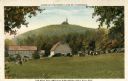
| Date: | 1920 |
|---|---|
| Description: | View of Holy Hill, with a field and the Hillside Hotel in the foreground. Captions read: "America's Favorite Place of Pilgrimage" and "The Holy Hill and Hi... |
| Date: | |
|---|---|
| Description: | Letterhead of Rural Route No. 3 in Bonduel, Wisconsin, with a man driving a U.S. R.F.D. mail wagon along a road by a fenced yard, a barn, and a mailbox. Pr... |

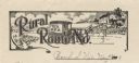
| Date: | |
|---|---|
| Description: | Letterhead of Rural Route No. 3 in Fall Creek, Wisconsin, with a woman in front of a house retrieving mail from a mailbox and a horse-drawn U.S. R.F.D. ma... |

| Date: | |
|---|---|
| Description: | Letterhead of the Post Office in Arkansaw, Wisconsin, with a uniformed man on horseback blowing a trumpet with a U.S. Mail banner streaming out of it. The ... |

| Date: | 1952 |
|---|---|
| Description: | This map shows counties, towns, cities, and selected villages, as well as the Menominee Indian Reservation are identified on this U.S. Post Office. Circles... |

| Date: | 1870 |
|---|---|
| Description: | A map of Iowa County, Wisconsin mounted on cloth that shows the villages of Avoca, Mifflin, Linden, Arena, Helena Station, Highland, Dodgeville, as well as... |

| Date: | 1943 |
|---|---|
| Description: | This 1943 map of Door County, Wisconsin, identifies the post offices and rural routes in the county. Highways and roads, cities and villages, and rural res... |

| Date: | 1970 |
|---|---|
| Description: | This map shows colored-coded land use with a legend in the bottom margin. Land classifications include: Year-round Residential (yellow), Seasonal Residenti... |

| Date: | 1973 |
|---|---|
| Description: | This map is 1 of 7 and includes a location map and township diagram in the margins. The map includes a key of land type: Residential (yellow), Commercial (... |

| Date: | 1973 |
|---|---|
| Description: | This map is 2 of 7 and includes a location map and township diagram in the bottom margin. The map includes a key of land type: Residential (yellow), Commer... |

| Date: | 1973 |
|---|---|
| Description: | This map is 3 of 7 and includes a location map and township diagram in the margins. The map includes a key of land type: Residential (yellow), Commercial (... |

| Date: | 1973 |
|---|---|
| Description: | This map is 4 of 7 and includes a location map and township diagram in the left margin. The map includes a key of land type: Residential (yellow), Commerci... |

| Date: | 1973 |
|---|---|
| Description: | This map is 5 of 7 and includes a location map and township diagram in the left margin. The map includes a key of land type: Residential (yellow), Commerci... |

| Date: | 1973 |
|---|---|
| Description: | This map is 6 of 7 and includes a location map and township diagram in the bottom margin. The map includes a key of land type: Residential (yellow), Commer... |

| Date: | 1973 |
|---|---|
| Description: | This map is 7 of 7 and includes a location map and township diagram in the left margin. The map includes a key of land type: Residential (yellow), Commerci... |
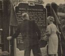
| Date: | 08 02 1967 |
|---|---|
| Description: | Mrs. A.V. Miller and James R. Sullivan unveiling the Rural Electrification historical marker together at the dedication ceremony outside of Richland Center... |
If you didn't find the material you searched for, our Library Reference Staff can help.
Call our reference desk at 608-264-6535 or email us at: