 Filter: Categories of Wisconsin Historical Images
Filter: FORMAT_TYPE of prints, photomechanical
Filter: Subject of learning and scholarship
Filter: Subject of church buildings
Filter: Categories of Wisconsin Historical Images
Filter: FORMAT_TYPE of prints, photomechanical
Filter: Subject of learning and scholarship
Filter: Subject of church buildings

| Date: | 1867 |
|---|---|
| Description: | Birds-eye drawing of Appleton, Outagamie Co., depicting street names and street layout, houses, the Fox River, the court house, jail, school houses, Lawren... |

| Date: | 1870 |
|---|---|
| Description: | Although the first European settlement in Jefferson was in 1836, the Village of Jefferson was first incorporated as a city in 1878. Made eight years earlie... |

| Date: | 1874 |
|---|---|
| Description: | Bird's-eye map of Racine, with an inset of Racine College. |
| Date: | |
|---|---|
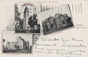
| Description: | Composite of three college buildings: College Chapel, Emerson Hall, and Science Hall. Caption reads: "A Group of College Buildings at Old Beloit." |
| Date: | 1905 |
|---|---|
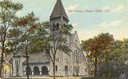
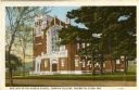
| Description: | View towards the chapel. Caption reads: "The College Chapel, Beloit, Wis." |
| Date: | 1895 |
|---|---|
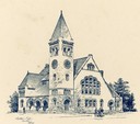
| Description: | Drawing of the Edward Dwight Eaton Chapel at Beloit College. |
| Date: | 1900 |
|---|---|
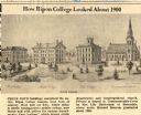
| Description: | Newspaper clipping, copy of lithograph, of how Ripon College looked in about 1900. Indicates West College, Middle College, East College and Congregational ... |
| Date: | 1910 |
|---|---|
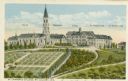
| Description: | Caption reads: "St. Lawrence College, Mt. Calvary, Wis." Locations are marked for the church, monastery, college building, St. Joseph's Hall, and St. Thoma... |
| Date: | |
|---|---|
| Description: | View of Our Lady of the Angels Chapel. Caption reads: "Our Lady of the Angels Chapel, Campion College, Prairie du Chien, Wis." |

| Date: | 1910 |
|---|---|
| Description: | View of Saint Paul's University Chapel at 723 State Street. Caption reads: "St. Paul's University Chapel, Madison, Wis." |

| Date: | 1920 |
|---|---|
| Description: | Elevated view looking west from the Wisconsin State Capitol dome. Caption reads: "Looking West from Capitol Dome, Madison, Wis." |

| Date: | 1860 |
|---|---|
| Description: | This map of Dodge County, Wisconsin, shows the township and range grid, towns, sections, cities and villages, railroads, roads, property owners and acreage... |

| Date: | 1918 |
|---|---|
| Description: | This map shows Madison and includes an index of University of Wisconsin buildings, city buildings, and churches. Lake Mendota, Lake Monona, and Lake Wingra... |

| Date: | 1929 |
|---|---|
| Description: | This is a blue line print map that shows local streets, railroads, local businesses, schools, parks, cemeteries, the airport, the state capitol, the Univer... |

| Date: | |
|---|---|
| Description: | Elevated view of State Street from the Capitol. A streetcar is coming up the street, and automobiles are parked along the curbs. Lake Mendota is in the bac... |
If you didn't find the material you searched for, our Library Reference Staff can help.
Call our reference desk at 608-264-6535 or email us at: