 Filter: Categories of Wisconsin Historical Images
Filter: FORMAT_TYPE of prints, photomechanical
Filter: Subject of learning and scholarship
Filter: Subject of country clubs
Filter: Categories of Wisconsin Historical Images
Filter: FORMAT_TYPE of prints, photomechanical
Filter: Subject of learning and scholarship
Filter: Subject of country clubs

| Date: | 1927 |
|---|---|
| Description: | Color map, hand-drawn with comic figures engaged in various activities throughout map. Bordered by the river on the left and Lake Michigan on the right, in... |
| Date: | 05 1938 |
|---|---|
| Description: | Map of the University of Wisconsin-Madison arboretum and wild life refuge. Roads are labelled, left to right: "Nakoma Road," "Monroe St.," "Manitou Way," "... |

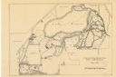
| Date: | 1932 |
|---|---|
| Description: | This map shows local streets, section lines, Nakoma Country Club, part of Lake Forest, and part of Lake Wingra. The map includes a legend showing areas of ... |

| Date: | 1971 |
|---|---|
| Description: | This map shows streets, highways, railroads, parks, colleges, cemeteries, county clubs, University of Wisconsin, Truax Field, Middleton, Shorewood Hills, M... |
If you didn't find the material you searched for, our Library Reference Staff can help.
Call our reference desk at 608-264-6535 or email us at: