 Filter: Categories of Wisconsin Historical Images
Filter: FORMAT_TYPE of prints, photomechanical
Filter: Subject of learning and scholarship
Filter: Subject of industries
Filter: Categories of Wisconsin Historical Images
Filter: FORMAT_TYPE of prints, photomechanical
Filter: Subject of learning and scholarship
Filter: Subject of industries

| Date: | 1867 |
|---|---|
| Description: | Birds-eye drawing of Appleton, Outagamie Co., depicting street names and street layout, houses, the Fox River, the court house, jail, school houses, Lawren... |

| Date: | 08 03 1905 |
|---|---|
| Description: | Photographic postcard of a scene of the Fox River near Lawrence University. The Main Building at Lawrence University can be seen in the background on the r... |
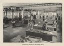
| Date: | 1910 |
|---|---|
| Description: | Students at work in the carpentry and woodworking shop at the Milwaukee School of Trades. |

| Date: | 1842 |
|---|---|
| Description: | This map shows portions of northern Illinois and Wisconsin surveyed by the map's creation. It shows county lines and university land, and depicts lead and ... |
If you didn't find the material you searched for, our Library Reference Staff can help.
Call our reference desk at 608-264-6535 or email us at:
