 Filter: Categories of Wisconsin Historical Images
Filter: FORMAT_TYPE of prints, photomechanical
Filter: Subject of lighthouses
Filter: Categories of Wisconsin Historical Images
Filter: FORMAT_TYPE of prints, photomechanical
Filter: Subject of lighthouses

| Date: | 1856 |
|---|---|
| Description: | View looking west from Lake Michigan with several steam ships and sailing vessels in harbor. There is a lighthouse to left of center, along shoreline. |
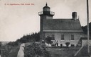
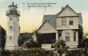
| Date: | |
|---|---|
| Description: | U.S. Lighthouse with people standing in the yard next to it. Caption reads: "U. S. Lighthouse, Fish Creek Wis." |
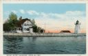
| Date: | 1920 |
|---|---|
| Description: | View across water toward the lighthouse. Caption reads: "Grassy Island Lighthouse, Green Bay, Wis." |
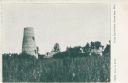
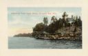
| Date: | 1898 |
|---|---|
| Description: | View across field towards the lighthouse and other buildings among trees. Caption reads: "Long Tail Point, Green Bay, Wis." |
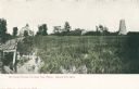
| Date: | 1910 |
|---|---|
| Description: | Caption reads: "Old Light House at Long Tail Point, Green Bay, Wis." Built in 1859. A marshy area is in the foreground, and a long pier leads to the new li... |

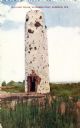
| Date: | 1930 |
|---|---|
| Description: | Caption reads: "'The Old Standby' First Lighthouse Built at the Head of Lake Superior—Superior Entry — 1854 Keepers, Com. Saxton and Samuel Palmer." |
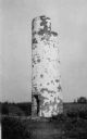
| Date: | 1910 |
|---|---|
| Description: | View of the remnants of the Minnesota Point Lighthouse. Faint caption at bottom reads: "Lighthouse". |
| Date: | 1907 |
|---|---|
| Description: | Caption reads: "Old Light House, Wisconsin Point, Superior, Wis." |
| Date: | 1915 |
|---|---|
| Description: | Colorized view of the Sherwood Point Lighthouse. Caption reads: "Sherwood Point Light House, Sturgeon Bay, Wis." |
| Date: | 1916 |
|---|---|
| Description: | South entrance to park. The bridge has stone lion sculptures on each of its corners, as well as ornate street lamps. A lighthouse and attached buildings ar... |
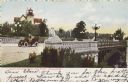
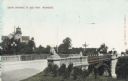
| Date: | 1905 |
|---|---|
| Description: | South entrance; an open car with two people is crossing the bridge. Stone lions flank the bridge on each corner. A lighthouse is in the background. Caption... |

| Date: | 1909 |
|---|---|
| Description: | View across lawn toward the bridge on the right. The lighthouse is in the background, as well as several other buildings in the distance. The bridge is fla... |
| Date: | 1910 |
|---|---|
| Description: | Old Government Lighthouse at Lake Park. The lighthouse is connected to a house, surrounded by shrubs. Caption reads: "The Old Government Lighthouse, Lake P... |

| Date: | 1957 |
|---|---|
| Description: | Large Letter style postcard for Green Bay depicting various scenes in the letters that spell the name of the city. Caption reads: "Greetings from Green Bay... |
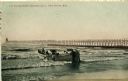
| Date: | 1908 |
|---|---|
| Description: | Group of men on a life saving crew launching a rowboat into Lake Michigan. A long pier with a lighthouse at the end bisects the horizon. Caption reads: "Li... |

| Date: | 1908 |
|---|---|
| Description: | A detailed map of Michigan Island and Gull Island in the Apostle Islands group (T51N, R1W, 4 M) that shows sections, landowners, the Michigan Island Lighth... |

| Date: | 1898 |
|---|---|
| Description: | This 1898 map of Ashland County, Wisconsin, shows the township and range grid, towns, sections, cities and villages, landownership, roads, railroads, swamp... |

| Date: | 1960 |
|---|---|
| Description: | This mid-20th century tourist brochure for Bayfield County, Wisconsin, includes a map of the county showing towns, cities and villages, highways and roads,... |

| Date: | 1967 |
|---|---|
| Description: | This tourist brochure for Bayfield County, Wisconsin, from 1967 includes a map of the county showing towns, cities and villages, highways and roads, railro... |

| Date: | 1950 |
|---|---|
| Description: | This map of Sturgeon Bay is part of the survey of the northern and northwestern lakes. The map shows lights, railroads, roads, and some public buildings. R... |
If you didn't find the material you searched for, our Library Reference Staff can help.
Call our reference desk at 608-264-6535 or email us at: