 Filter: Categories of Wisconsin Historical Images
Filter: FORMAT_TYPE of prints, photomechanical
Filter: Subject of military art and science
Filter: County of Columbia
Filter: Categories of Wisconsin Historical Images
Filter: FORMAT_TYPE of prints, photomechanical
Filter: Subject of military art and science
Filter: County of Columbia
| Date: | |
|---|---|
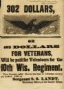
| Description: | Recruiting poster that reads "302 Dollars or 402 Dollars for Veterans will be paid for Volunteers for the 10th Wis. Regiment". |

| Date: | 1855 |
|---|---|
| Description: | Fox-Wisconsin portage and canal map, when the canal was not yet built. From a map in the office of the city clerk at Portage. "The old trail, the location ... |

| Date: | 1831 |
|---|---|
| Description: | Fort Winnebago, a print published in Mrs. John H. Kinzie's Wau-bun (1856). |
| Date: | 1930 |
|---|---|
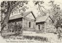
| Description: | A sketch of the surgeon's quarters at Fort Winnebago. Caption reads: "Fort Winnebago Surgeons' Quarter". |
| Date: | |
|---|---|
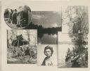
| Description: | Composite photograph of scenes of Winnebago Indians. |

| Date: | 1800 |
|---|---|
| Description: | This map shows the land claim owned by the Portage Canal Company and includes an index of landownership and landmarks. The Wisconsin and Portage River, the... |
| Date: | 1909 |
|---|---|
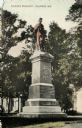
| Description: | Color-enhanced black and white photographic postcard of the Soldier's Monument in honor of the Grand Army of the Republic during the Civil War. Caption rea... |

| Date: | 1836 |
|---|---|
| Description: | This map shows lot and block numbers, streets, a proposed canal basin, Fort Winnebago, and the Wisconsin and Fox Rivers. Relief is shown by hachures and no... |

| Date: | 1855 |
|---|---|
| Description: | This map shows landownership, lot and block numbers, streets, a canal, bridges, Fort Winnebago, the Wisconsin River, and the Fox River. Relief is shown by ... |

| Date: | 1914 |
|---|---|
| Description: | This photostat map shows Fort Winnebago around 1931, land to be reserved for military purposes, roads to Fort Howard and Fort Crawford, "private property" ... |
If you didn't find the material you searched for, our Library Reference Staff can help.
Call our reference desk at 608-264-6535 or email us at: