 Filter: Categories of Wisconsin Historical Images
Filter: FORMAT_TYPE of prints, photomechanical
Filter: Subject of military art and science
Filter: Subject of marshes
Filter: Categories of Wisconsin Historical Images
Filter: FORMAT_TYPE of prints, photomechanical
Filter: Subject of military art and science
Filter: Subject of marshes

| Date: | 1847 |
|---|---|
| Description: | A hand-colored map that shows the area south and east of the Wisconsin and Fox Rivers, as well as a few landmarks just north of that area. The township gri... |

| Date: | 1869 |
|---|---|
| Description: | Map shows townships and sections, landownership and acreages, buildings, and marshes. The map includes insets of Franklin, Hales Corners, Bay View, Oak Cre... |

| Date: | 1900 |
|---|---|
| Description: | This photostat of a manuscript map originally drawn in 1829 shows landownership, buildings, including Fort Howard and U.S. sawmill, swamps, public barns an... |

| Date: | 1766 |
|---|---|
| Description: | Map of the region south of Lake Erie to the Ohio River. It shows forts, towns, Native American towns, mines, roads, mountains, swamps, lakes, and rivers. T... |
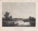
| Date: | 1858 |
|---|---|
| Description: | Engraved print of four men and a dog in a boat on Lake Winnebago. Two of the men are in the center of the boat holding hunting rifles, while one man is sta... |
If you didn't find the material you searched for, our Library Reference Staff can help.
Call our reference desk at 608-264-6535 or email us at: