 Filter: Categories of Wisconsin Historical Images
Filter: FORMAT_TYPE of prints, photomechanical
Filter: Subject of military bases
Filter: Subject of transportation
Filter: Categories of Wisconsin Historical Images
Filter: FORMAT_TYPE of prints, photomechanical
Filter: Subject of military bases
Filter: Subject of transportation

| Date: | 07 1941 |
|---|---|
| Description: | Advertising proof for International trucks, featuring color illustrations of a truck and the United States, largely in red, white and blue. Includes the te... |
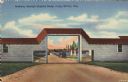
| Date: | |
|---|---|
| Description: | Colorized postcard view of an arch at Camp McCoy with ramps on either side and a road passing through it. Parked cars and barracks are on the far side of t... |

| Date: | 1735 |
|---|---|
| Description: | Map of the Chesapeake Bay region and surrounding areas, with north oriented towards the right. A few forts, rivers, and bays are labeled, as are the region... |

| Date: | 1780 |
|---|---|
| Description: | Detailed topographical and political map of the area from Lake Champlain to Albany and the Hudson River. Relief is shown through hachures. The map shows ci... |

| Date: | 1795 |
|---|---|
| Description: | Map of the new state of Tennessee. It shows borders, numerous boundary lines (particularly Native American boundaries), towns (European and Native American... |

| Date: | 1796 |
|---|---|
| Description: | Map of the new state of Tennessee. It shows borders, numerous boundary lines (particularly Native American boundaries), towns (European and Native American... |

| Date: | 1800 |
|---|---|
| Description: | Map of the new state of Tennessee. It shows borders, numerous boundary lines (particularly Native American boundaries), towns (European and Native American... |

| Date: | 1795 |
|---|---|
| Description: | Detailed map of Kentucky showing counties, cities, towns, Native American towns, forts, salt licks, roads, prairies, mountains, lakes, and rivers. Numerous... |

| Date: | 1793 |
|---|---|
| Description: | Detailed topographical map of the Ohio River between Clarkville and Louisville. It shows plots of farmland, forest, islands, garden plots, houses, Fort Fe... |

| Date: | 1766 |
|---|---|
| Description: | Map of the region south of Lake Erie to the Ohio River. It shows forts, towns, Native American towns, mines, roads, mountains, swamps, lakes, and rivers. T... |

| Date: | 1755 |
|---|---|
| Description: | Map of the Great Lakes region during the French and Indian War. It shows in great detail the territories, borders and boundary lines, Native American tribe... |

| Date: | 1851 |
|---|---|
| Description: | Elevated view across water towards Fort Howard. In the foreground is a man standing on a pier, and in the water nearby are five men rowing in a boat. Capti... |
If you didn't find the material you searched for, our Library Reference Staff can help.
Call our reference desk at 608-264-6535 or email us at: