 Filter: Categories of Wisconsin Historical Images
Filter: FORMAT_TYPE of prints, photomechanical
Filter: Subject of mounds
Filter: County of Dane
Filter: Categories of Wisconsin Historical Images
Filter: FORMAT_TYPE of prints, photomechanical
Filter: Subject of mounds
Filter: County of Dane
| Date: | |
|---|---|
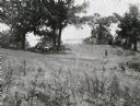
| Description: | Two men enjoy the shade among Native American burial mounds on the Dividing Ridge, a recessional moraine, between Lakes Monona and Wingra in Madison, Wisco... |
| Date: | 1919 |
|---|---|
| Description: | A goose effigy mound outlined with lime, on the grounds of the Black Hawk Country Club. The folded wings are characteristic of goose effigies in the area o... |
| Date: | |
|---|---|
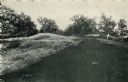
| Description: | A row of conical mounds at Morris Park on the west side of Lake Mendota, in or near Governor Nelson State Park. |

| Date: | |
|---|---|
| Description: | A large burial mound near the south side of Governor Nelson State Park. |

| Date: | |
|---|---|
| Description: | Wisconsin Memorial Hospital with a key to buildings in the upper left. Indian mounds are marked on the site. Arthur Peabody was the state architect for th... |

| Date: | 1927 |
|---|---|
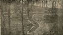
| Description: | Blueprint-style map of Frost Woods on the shore of Lake Monona. The map indicates the locations of Indian mounds, an Indian camp, and various plants. There... |

| Date: | 1892 |
|---|---|
| Description: | Topographical map of Madison and surrounding communities which include Lake Mendota, Lake Monona, Lake Waubesa and Lake Kegonsa. The red dots on the map sh... |

| Date: | 1844 |
|---|---|
| Description: | Part of a series of local maps, showing a number of burial mounds in the shape of animals near Madison, Wisconsin along military road. The maps also show d... |

| Date: | 1892 |
|---|---|
| Description: | This map oriented with north to the upper left shows railroads, creeks, post offices, smaller lakes, Lake Mendota, Lake Monona, Lake Wingra, Lake Waubesa, ... |

| Date: | 1974 |
|---|---|
| Description: | This 1974 map is a reproduction of the original survey maps of the Four Lakes region of Dane County, Wisconsin. It shows sections, lakes, rivers, wetlands,... |

| Date: | 1873 |
|---|---|
| Description: | A map of the township of Primrose from the "Atlas of Dane County." |

| Date: | 1924 |
|---|---|
| Description: | This pictorial map focuses on the Madison Isthmus, Lake Mendota, Lake Monona, Lake Wingra, and shows points of historical interest, buildings, parks, and I... |

| Date: | 1933 |
|---|---|
| Description: | Blue print and blue line print maps that show local streets, Nakoma Country Club, part of Lake Forest, and part of Lake Wingra. A legend is included that s... |

| Date: | 10 1911 |
|---|---|
| Description: | This map shows lot numbers, building lines, roads, trees, and Indian mounds. Relief is shown by contours. Includes manuscript annotations marking parks. |
If you didn't find the material you searched for, our Library Reference Staff can help.
Call our reference desk at 608-264-6535 or email us at: