 Filter: Categories of Wisconsin Historical Images
Filter: FORMAT_TYPE of prints, photomechanical
Filter: Subject of parks
Filter: Subject of bicycles
Filter: Categories of Wisconsin Historical Images
Filter: FORMAT_TYPE of prints, photomechanical
Filter: Subject of parks
Filter: Subject of bicycles
| Date: | |
|---|---|
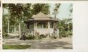
| Description: | Visitors around a gazebo or pavilion in Washington Park. A group of people are posing on the curved stairway on the right side of the pavilion. Caption rea... |
| Date: | |
|---|---|
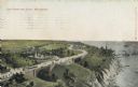
| Description: | Elevated view with the lake on the right, with a number of boats near the shoreline. There is a long winding road through the park, including bridges, a fo... |

| Date: | 1987 |
|---|---|
| Description: | This 1987 map of Racine and Kenosha counties, Wisconsin, shows towns, sections, cities and villages, zip code boundaries, highways and roads, bicycle route... |
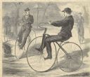
| Date: | 1886 |
|---|---|
| Description: | Engraved image from a sketch by Theodore Davis showing four men bicycling. |

| Date: | 1992 |
|---|---|
| Description: | This guide features a map of suggested bike routes. Also included is a legend, text on how to use the map and legend, points of interest, safety tips, and ... |

| Date: | 2008 |
|---|---|
| Description: | This double sided map shows roads, railroads, biking trails, civil townships, parks, wildlife refuges, town halls, and hospitals. The region map covers par... |

| Date: | 2004 |
|---|---|
| Description: | This map shows ATMs, houses of worship, hotels, parking ramps, public parking, union cab stands, bus stops, business district, parks and public areas, gove... |

| Date: | 2005 |
|---|---|
| Description: | This map shows dams and falls, areas of portage, canoe and kayak access, boat launches, parking, restrooms, picnic areas, dining, rapid water, parks, and b... |
If you didn't find the material you searched for, our Library Reference Staff can help.
Call our reference desk at 608-264-6535 or email us at: