 Filter: Categories of Wisconsin Historical Images
Filter: FORMAT_TYPE of prints, photomechanical
Filter: Subject of parks
Filter: Subject of church buildings
Filter: Categories of Wisconsin Historical Images
Filter: FORMAT_TYPE of prints, photomechanical
Filter: Subject of parks
Filter: Subject of church buildings

| Date: | 1882 |
|---|---|
| Description: | Bird's-eye views of various sections of Milwaukee. |

| Date: | 1892 |
|---|---|
| Description: | Bird's-eye view of Chicago, with ships in the Lake Michigan harbor. |

| Date: | 1905 |
|---|---|
| Description: | Clockwise from upper left images include: Cutters Point, Long Lake, Wis.; M.E. Church, New Auburn, Wis.; Farmers Store, New Auburn, Wis.; Public School, Ne... |
| Date: | 1900 |
|---|---|
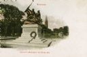
| Description: | Soldier's Monument on Grand Avenue, with a wreath places at the base. Steeples of a church are in the background. Scroll work has been added to the upper a... |
| Date: | 1910 |
|---|---|
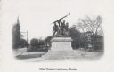
| Description: | Grand Avenue (now Wisconsin Avenue). A church building is in the background on the left. Caption reads: "Soldiers' Monument, Grand Avenue, Milwaukee." |
| Date: | 1912 |
|---|---|
| Description: | Now called Wisconsin Avenue. Split avenue (strip of land down the center). There are several statues on plinths and/or columns in the median. Caption reads... |
| Date: | 1912 |
|---|---|
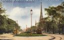
| Description: | Now called Wisconsin Avenue. On the left are trees and a trolley in the road. On the right are several church towers, more trees, and another trolley. In t... |

| Date: | 1920 |
|---|---|
| Description: | Elevated view looking east from Eleventh Street. The avenue is lined with buildings and trees. A large flagpole is in the center of the avenue which is lan... |

| Date: | 1905 |
|---|---|
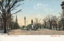
| Description: | View down center of avenue. Horse-drawn vehicles are on the road and pedestrians are on the sidewalk. Caption reads: "Grand Ave. Blvd., Milwaukee, Wis." |
| Date: | |
|---|---|
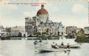
| Description: | St. Josephat Church and School from Kosciuszko Park. The classic style church with dome is across a body of water. Three boats with boaters are out rowing ... |

| Date: | 1912 |
|---|---|
| Description: | Church and school seen from Kosciuszko Park. Located across a lake, behind some trees and bushes. A woman is sitting on some decorative stones next to the ... |

| Date: | 1915 |
|---|---|
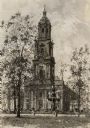
| Description: | A fountain and trees in Courthouse Square (now Cathedral Square) in front of the church. Caption reads: "St. John's Cathedral from Court House Park, Milwau... |
| Date: | |
|---|---|
| Description: | Drawing of a fountain and trees in Courthouse Square (now Cathedral Square) in front of the church. |

| Date: | 1900 |
|---|---|
| Description: | Washington Monument on Grand Avenue with a streetcar coming up the street in the background. Caption reads: "Washington Monument on Grand Ave., Milwaukee." |

| Date: | |
|---|---|
| Description: | View of the Washington Monument enclosed in a fence on a median. Caption reads: "Washington Monument, Grant Ave. Park, Milwaukee, Wis." |

| Date: | 1946 |
|---|---|
| Description: | A map showing the roads, railroads, towns, cities and villages, streams and lakes, airports, schools, churches, cemeteries, and golf courses in Kenosha Cou... |

| Date: | 1891 |
|---|---|
| Description: | A hand-colored map of Milwaukee County, Wisconsin that shows the township and range system, sections, towns, roads, railroads and rail stations, cities and... |

| Date: | 1902 |
|---|---|
| Description: | A map of Milwaukee County, Wisconsin that shows the township and range system, sections, towns, roads, railroads and rail stations, cities and villages, po... |

| Date: | 1898 |
|---|---|
| Description: | Map showing the contour depths of the lakes in northwestern Waukesha County, Wisconsin. Roads, railroads, depots, churches, schools, and hotels in the area... |

| Date: | 1903 |
|---|---|
| Description: | Map shows location of government buildings, schools, churches, parks, and other points of interest. The upper left hand margin features a "Reference" secti... |
If you didn't find the material you searched for, our Library Reference Staff can help.
Call our reference desk at 608-264-6535 or email us at: