 Filter: Categories of Wisconsin Historical Images
Filter: FORMAT_TYPE of prints, photomechanical
Filter: Subject of parks
Filter: Subject of landforms
Filter: Categories of Wisconsin Historical Images
Filter: FORMAT_TYPE of prints, photomechanical
Filter: Subject of parks
Filter: Subject of landforms

| Date: | 1896 |
|---|---|
| Description: | A portion of John B. Heim's map of the Water Works System of Madison showing the size of the third Wisconsin Capitol (228' x 226') in comparison with the C... |

| Date: | 1892 |
|---|---|
| Description: | Bird's-eye view of Chicago, with ships in the Lake Michigan harbor. |

| Date: | 1930 |
|---|---|
| Description: | Pictorial map of Glacier National Park, Montana and Waterton Lakes National Park, Alberta. Illustrated by Joe Scheurle, it depicts white people, American ... |

| Date: | 1909 |
|---|---|
| Description: | Streets, Lake Wingra, Lake Mendota, and Lake Monona are all labelled. Map reads: "The present park system of Madison comprises 150 acres of improved parks,... |

| Date: | 1960 |
|---|---|
| Description: | View across water towards a man, woman, and two children standing on the rock ledge at Cave Point. Lake Michigan is on the right. |
| Date: | 1910 |
|---|---|
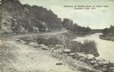
| Description: | A curving, rutted dirt road between a rock wall at Duncan Creek in Irvine Park (probably the "Bear Cage Road"). Caption reads: "Driveway at Duncan Creek in... |

| Date: | 1910 |
|---|---|
| Description: | Colorized view of a rutted dirt road next to a rock face in Irvine Park. Caption reads: "A Rocky Scene In Irvine Park, Chippewa Falls, Wis." |

| Date: | 1920 |
|---|---|
| Description: | A tree-lined rock face next to Duncan Creek in Irvine Park in Chippewa Falls. Caption reads: "A Beautiful Scene in Irvine Park, Chippewa Falls, Wis." |

| Date: | 1899 |
|---|---|
| Description: | A plat map showing Lake Monona, the isthmus in Madison, and the towns of Burke and Blooming Grove. |
| Date: | 1953 |
|---|---|
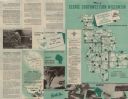
| Description: | This map shows the locations of many scenic areas in La Crosse, Vernon, Crawford, Richland, Grant, and Iowa Counties. On the front side of the map, there i... |

| Date: | 1980 |
|---|---|
| Description: | Aerial shot directly over Picnic Point. Boats are in the lake. Text on reverse reads: "Picnic Point — A peninsula of the University of Wisconsin campus jut... |
| Date: | 1967 |
|---|---|
| Description: | Schematic Master Plan for the City of Madison, Wisconsin. William Wesley Peters, Architect • The Frank Lloyd Wright Foundation. |

| Date: | 1914 |
|---|---|
| Description: | Text on front reads: "Interstate Park. Dells of the St. Croix." Elevated view of the Dells of the St. Croix River between Wisconsin and Minnesota. Text on ... |

| Date: | 12 13 1913 |
|---|---|
| Description: | Text on front reads: "Bird's Eye View from Devil's Doorway. Devil's Lake, Wis." Elevated view of the rock formation called the Devil's Doorway in Devil's L... |

| Date: | 1950 |
|---|---|
| Description: | Text on front reads: "Sioux River." On reverse: "Big Rock on Sioux River. Washburn, Wisconsin. A thrilling day of trout fishing and picnicking at the Big R... |
If you didn't find the material you searched for, our Library Reference Staff can help.
Call our reference desk at 608-264-6535 or email us at: