 Filter: Categories of Wisconsin Historical Images
Filter: FORMAT_TYPE of prints, photomechanical
Filter: Subject of parks
Filter: Subject of michigan, lake
Filter: Categories of Wisconsin Historical Images
Filter: FORMAT_TYPE of prints, photomechanical
Filter: Subject of parks
Filter: Subject of michigan, lake

| Date: | 1927 |
|---|---|
| Description: | Color map, hand-drawn with comic figures engaged in various activities throughout map. Bordered by the river on the left and Lake Michigan on the right, in... |

| Date: | 1892 |
|---|---|
| Description: | Bird's-eye view of Chicago, with ships in the Lake Michigan harbor. |
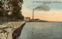
| Date: | 1918 |
|---|---|
| Description: | The Lake Michigan shoreline from Eichelman Park. In the distance is a smokestack and industrial buildings. Caption reads: "Scene on Lake Michigan from Eich... |
| Date: | |
|---|---|
| Description: | Train station in the distance, with a man standing in the foreground on steps leading down to the lake, near a fenced-in pond. On the left are railroad tra... |
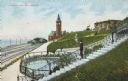
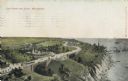
| Date: | 1910 |
|---|---|
| Description: | View along top of hill in the park toward a woman and child sitting on a bench near the monument. At the bottom of the hill on the left are railroad tracks... |

| Date: | 1910 |
|---|---|
| Description: | Elevated view over trees and bushes toward the footbridge. A building with a red roof is on the far right. Beyond the bridge is Lake Michigan. Caption read... |

| Date: | |
|---|---|
| Description: | View looking down toward a curving stairway leading down to a terrace with columns and ornate railings. In the background is a flagpole on the overlook to ... |
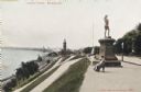
| Date: | |
|---|---|
| Description: | View down curving road lined with flowering bushes toward a bridge in Lake Park. Lake Michigan is in the distance, with a ship at the horizon. Caption read... |
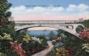
| Date: | |
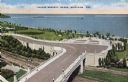
|---|---|
| Description: | Elevated view of Lincoln Memorial Bridge and plaza area. Lake Michigan is in the background, railroad tracks are below the bridge. Trees and grass surround... |

| Date: | |
|---|---|
| Description: | Elevated view of water tower and Water Tower Park with Lake Michigan in the background. Caption reads: "Water Tower and Water Tower Park, Milwaukee, Wis." |
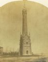
| Date: | 1870 |
|---|---|
| Description: | Water tower of the Milwaukee water works, North Point. |

| Date: | 1905 |
|---|---|
| Description: | Elevated view of Water Tower and park with Milwaukee Bay in background. Caption reads: "Water Tower and Park with view of Milwaukee Bay, Milwaukee." |
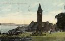
| Date: | 1910 |
|---|---|
| Description: | Chicago & Northwestern Railway Depot, with train shed and clock tower. In the foreground is a landscaped area with flowers. In the background is Lake Mich... |
| Date: | |
|---|---|
| Description: | Elevated view with the lake on the right, with a number of boats near the shoreline. There is a long winding road through the park, including bridges, a fo... |

| Date: | 1878 |
|---|---|
| Description: | This map shows block numbers, wards, roads, railroads, parks, and selected buildings and includes a "Milwaukee city street guide" as well as a guide to pub... |

| Date: | 1887 |
|---|---|
| Description: | This map shows block numbers, roads, railroads, wards, and selected buildings. The map includes a "Milwaukee city street guide" and index to public buildin... |

| Date: | 1941 |
|---|---|
| Description: | A map of the area south of Ripon and Sheboygan and east of Waterloo and Janesville, showing the route of the Chicago, North Shore and Milwaukee Railroad in... |

| Date: | 1939 |
|---|---|
| Description: | This nine-part map from the U.S. Bureau of Public Roads identifies federal and state highways in Wisconsin by pavement type. County, forest, park, and publ... |

| Date: | 1944 |
|---|---|
| Description: | This nine-part map from the U.S. Bureau of Public Roads identifies federal and state highways in Wisconsin by pavement type. County, forest, park, and publ... |

| Date: | 1946 |
|---|---|
| Description: | A map showing the roads, railroads, towns, cities and villages, streams and lakes, airports, schools, churches, cemeteries, and golf courses in Kenosha Cou... |
If you didn't find the material you searched for, our Library Reference Staff can help.
Call our reference desk at 608-264-6535 or email us at: