 Filter: Categories of Wisconsin Historical Images
Filter: FORMAT_TYPE of prints, photomechanical
Filter: Subject of parks
Filter: Subject of neighborhoods
Filter: Categories of Wisconsin Historical Images
Filter: FORMAT_TYPE of prints, photomechanical
Filter: Subject of parks
Filter: Subject of neighborhoods
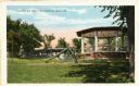
| Date: | 1920 |
|---|---|
| Description: | View of Riverview Park, with gazebo and slide in foreground. Caption reads: "Riverview Park, Watertown, Wis." |

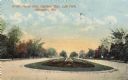
| Date: | 1913 |
|---|---|
| Description: | Panoramic view of Tenney Park showing Marston Bridge. |

| Date: | 1920 |
|---|---|
| Description: | View across water towards an excursion boat moored at the shoreline of Riverside Park. There are houses beyond, and in the distance is a smokestack. Captio... |
| Date: | 1910 |
|---|---|
| Description: | The postcard caption is in error in its reference to Lake Park, which is distantly located from this street. Possibly Highland Park was intended. A second ... |

| Date: | 1905 |
|---|---|
| Description: | View across road toward the building which is surrounded by a fence. Caption reads: "The Riverside Sanitarium, Menlo Park, Milwaukee." |

| Date: | 1878 |
|---|---|
| Description: | This map shows block numbers, wards, roads, railroads, parks, and selected buildings and includes a "Milwaukee city street guide" as well as a guide to pub... |

| Date: | 1887 |
|---|---|
| Description: | This map shows block numbers, roads, railroads, wards, and selected buildings. The map includes a "Milwaukee city street guide" and index to public buildin... |
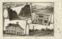
| Date: | 1905 |
|---|---|
| Description: | Photographic postcard of a collage of 5 views of Brandon including; Washington St., Public Square, Times Office, High School, and Depot & Park. |

| Date: | 1954 |
|---|---|
| Description: | This map of La Crosse shows residential, multiple dwelling, local business, commercial, light industrial, heavy industrial and special multiple dwelling la... |

| Date: | 1972 |
|---|---|
| Description: | This map of La Crosse is a plan for the city parks and recreation areas. The cover features an explanation of the Park and Recreation plan, objectives of t... |

| Date: | 1888 |
|---|---|
| Description: | This map has relief shown by hachures and features inset maps of a plat of E.D. Clinton and Blackwell’s add’n to the City of La Crosse. Wards (1-10) shaded... |

| Date: | 1915 |
|---|---|
| Description: | This map is mounted on cloth and shows lots and landownership, selected buildings, roads, railroads, parks, cemeteries, city wards, and includes advertisem... |

| Date: | 1951 |
|---|---|
| Description: | This map shows streets, railroads, Lake Mendota, Lake Monona, Lake Wingra, golf courses, parks, Truax Field, and country clubs. Also included are street, c... |

| Date: | 1923 |
|---|---|
| Description: | Map showing the parcel of land on the shore of Lake Monona acquired by the City of Madison for a park (today known as Olbrich Park). |

| Date: | 1880 |
|---|---|
| Description: | This map shows wards, roads, railroads, lot and block numbers, subdivisions, parks, and some landownership. A handwritten annotation in red reads: "Note: S... |
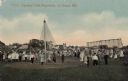
| Date: | |
|---|---|
| Description: | Hand-colored view of a group of children at a playground with swings, see-saws and a slide. Caption reads: "Copeland Park Playground, La Crosse, Wis." |

| Date: | 06 03 1911 |
|---|---|
| Description: | Text on front reads: "Maid of the Mist, Gillett Park, Tomah, Wis." A stone fountain with a statue of a woman in the center, holding a water vessel on her s... |

| Date: | 1907 |
|---|---|
| Description: | Text on front reads: "Birge Fountain. Whitewater, Wis." The Neoclassical-style Birge Fountain, located in Flat Iron Park. Mythical figures decorate the foo... |
If you didn't find the material you searched for, our Library Reference Staff can help.
Call our reference desk at 608-264-6535 or email us at: