 Filter: Categories of Wisconsin Historical Images
Filter: FORMAT_TYPE of prints, photomechanical
Filter: Subject of parks
Filter: Subject of streets
Filter: Categories of Wisconsin Historical Images
Filter: FORMAT_TYPE of prints, photomechanical
Filter: Subject of parks
Filter: Subject of streets

| Date: | 1890 |
|---|---|
| Description: | Bird's-eye map of Ashland, viewed from Lake Superior, with insets of Prentice Park and Fishery. Population 16,000. Increase in Ten Years, 11,000. |

| Date: | 1896 |
|---|---|
| Description: | A portion of John B. Heim's map of the Water Works System of Madison showing the size of the third Wisconsin Capitol (228' x 226') in comparison with the C... |

| Date: | 1892 |
|---|---|
| Description: | Bird's-eye view of Chicago, with ships in the Lake Michigan harbor. |
| Date: | 1925 |
|---|---|
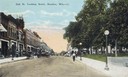
| Description: | View down Oak Street, with storefronts on the left, and a park on the right. Caption reads: "Oak St. Looking South, Baraboo, Wis." |
| Date: | 1908 |
|---|---|
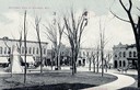
| Description: | Downtown view of Baraboo featuring multiple buildings around the square, a monument, and a horse and buggy. Caption reads: "Sectional View of Baraboo, Wis.... |

| Date: | |
|---|---|
| Description: | Poster advertising the Elmside lots for summer homes by Lake Monona. |

| Date: | 1904 |
|---|---|
| Description: | This map shows a plat of the east part of the city, numbered blocks and lots, some landownership, local streets, roads, railroads, wards by number, parks, ... |

| Date: | 1904 |
|---|---|
| Description: | This map shows a plat of the west part of the city, numbered blocks and lots, some landownership, local streets, roads, railroads, wards by number, parks, ... |

| Date: | 1920 |
|---|---|
| Description: | View across street towards of Fountain Park. Caption reads: "Fountain Park, Sheboygan, Wis." |

| Date: | |
|---|---|
| Description: | Plat map of the east central part of the city. |

| Date: | 1913 |
|---|---|
| Description: | Panoramic view of Tenney Park showing Marston Bridge. |
| Date: | 1908 |
|---|---|
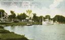
| Description: | View from shoreline towards a large boat, perhaps an excursion boat, and sailboats docked further down along the curving shoreline. Beyond the boats is a t... |
| Date: | |
|---|---|
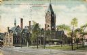
| Description: | Angled view across street toward a park on the right and the railroad station behind. The station has blue roofs, chimneys, and a clocktower. Several vehic... |

| Date: | 1900 |
|---|---|
| Description: | Washington Monument on Grand Avenue with a streetcar coming up the street in the background. Caption reads: "Washington Monument on Grand Ave., Milwaukee." |

| Date: | |
|---|---|
| Description: | View of the Washington Monument enclosed in a fence on a median. Caption reads: "Washington Monument, Grant Ave. Park, Milwaukee, Wis." |

| Date: | 1854 |
|---|---|
| Description: | This map is ink and watercolor on tracing cloth and shows lot and block numbers, streets, a park, and depots. Some lots are colored red or blue and some in... |

| Date: | 1970 |
|---|---|
| Description: | A map of parks of Kewaunee County, Wisconsin, showing the fishing spots, lakes and parks in the area, it also provides a location map of the area. On the ... |

| Date: | 1891 |
|---|---|
| Description: | A hand-colored map of Milwaukee County, Wisconsin that shows the township and range system, sections, towns, roads, railroads and rail stations, cities and... |

| Date: | 1940 |
|---|---|
| Description: | Map of Milwaukee County showing the metropolitan area, in yellow, and the proposed connecting of parkways and boulevards in green. The map also identifies ... |

| Date: | 1976 |
|---|---|
| Description: | A street map of Milwaukee County, Wisconsin that identifies the location of schools, hospitals, parks, beaches, streets, freeways, both planned or under co... |
If you didn't find the material you searched for, our Library Reference Staff can help.
Call our reference desk at 608-264-6535 or email us at: