 Filter: Categories of Wisconsin Historical Images
Filter: FORMAT_TYPE of prints, photomechanical
Filter: Subject of parks
Filter: Subject of water
Filter: Categories of Wisconsin Historical Images
Filter: FORMAT_TYPE of prints, photomechanical
Filter: Subject of parks
Filter: Subject of water

| Date: | 1890 |
|---|---|
| Description: | Bird's-eye map of Ashland, viewed from Lake Superior, with insets of Prentice Park and Fishery. Population 16,000. Increase in Ten Years, 11,000. |
| Date: | |
|---|---|
| Description: | View from a stone bridge towards Vilas Park, with children riding the carousel (merry-go-round) and a kiddie train adjacent to the lagoon. |

| Date: | 1882 |
|---|---|
| Description: | Bird's-eye map of Lake Geneva, looking southwest, with insets of points of interest. |

| Date: | 1927 |
|---|---|
| Description: | Color map, hand-drawn with comic figures engaged in various activities throughout map. Bordered by the river on the left and Lake Michigan on the right, in... |

| Date: | 1896 |
|---|---|
| Description: | A portion of John B. Heim's map of the Water Works System of Madison showing the size of the third Wisconsin Capitol (228' x 226') in comparison with the C... |

| Date: | 1892 |
|---|---|
| Description: | Bird's-eye view of Chicago, with ships in the Lake Michigan harbor. |
| Date: | 1905 |
|---|---|
| Description: | Elevated view of Bay Beach. Caption reads: "Bay Beach, Green Bay, Wis." |
| Date: | |
|---|---|
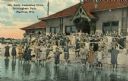
| Description: | A colorized image of a girls' swimming class at the Brittingham Park bathhouse. Caption reads: "Girls' Swimming Class, Brittingham Park, Madison, Wis." |

| Date: | 1915 |
|---|---|
| Description: | Colorized view. Caption reads: "Chautauqua Grounds, Lake Monona, Madison in Distance." |

| Date: | |
|---|---|
| Description: | Poster advertising the Elmside lots for summer homes by Lake Monona. |

| Date: | 1908 |
|---|---|
| Description: | View towards people standing on the shoreline near a boat landing at Yosts Park. A man and a dog are standing on the pier, and a group of people are in a b... |
| Date: | 1918 |
|---|---|
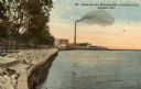
| Description: | The Lake Michigan shoreline from Eichelman Park. In the distance is a smokestack and industrial buildings. Caption reads: "Scene on Lake Michigan from Eich... |

| Date: | 1904 |
|---|---|
| Description: | This map shows a plat of the east part of the city, numbered blocks and lots, some landownership, local streets, roads, railroads, wards by number, parks, ... |
| Date: | 1914 |
|---|---|
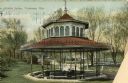
| Description: | View of people at Silurian Spring, located in Waukesha Springs Park. Caption reads: "Silurian Spring, Waukesha, Wis." |

| Date: | 1905 |
|---|---|
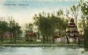
| Description: | View of the Bethesda Spring. Caption reads: "Bethesda Spring, Waukesha, Wis." |
| Date: | 1910 |
|---|---|
| Description: | View of Bethesda Spring. Caption reads: "Bethesda Spring, Waukesha, Wis." |

| Date: | 1904 |
|---|---|
| Description: | This map shows a plat of the west part of the city, numbered blocks and lots, some landownership, local streets, roads, railroads, wards by number, parks, ... |
| Date: | 1910 |
|---|---|
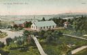
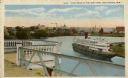
| Description: | Elevated view of Manitowoc from Riverview Park. A large boat is in the bend of the river. In the foreground is a railing and an extended overlook over the ... |
| Date: | 1909 |
|---|---|
| Description: | View across water toward Colladay Park on Lake Kegonsa. Cabins are on the shoreline among trees. Caption reads: Colladay Park, Lake Kegonsa." |
| Date: | 1925 |
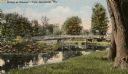
|---|---|
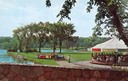
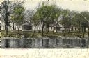
| Description: | View from shoreline towards a bridge in Gleason's Park. Caption reads: "Bridge at Gleason's Park, Marshfield, Wis." |
If you didn't find the material you searched for, our Library Reference Staff can help.
Call our reference desk at 608-264-6535 or email us at: