 Filter: Categories of Wisconsin Historical Images
Filter: FORMAT_TYPE of prints, photomechanical
Filter: Subject of peninsulas
Filter: Categories of Wisconsin Historical Images
Filter: FORMAT_TYPE of prints, photomechanical
Filter: Subject of peninsulas

| Date: | 1883 |
|---|---|
| Description: | Bird's-eye map of Superior, county seat of Douglas County, on the shores of Lake Superior, with insets of points of interest. |
| Date: | 1900 |
|---|---|
| Description: | Picnic Point from shoreline of Lake Mendota at the University of Wisconsin-Madison campus. There is a university building on the hill on the left, and a pi... |

| Date: | 1899 |
|---|---|
| Description: | Map of Door County with inset photograph of Sturgeon Bay City. |

| Date: | 1951 |
|---|---|
| Description: | Water depths shown by bathymetric tints and soundings. Relief shown by contours. "Depths in feet." "Aids to navigation corrected to May 4, 1951." On verso:... |
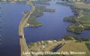
| Date: | 1950 |
|---|---|
| Description: | Color photograph of an aerial view of Lake Wissota looking east on Highway 29. Many resorts are in the area. Lake Wissota is one of the largest man-made la... |
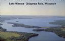
| Date: | 1950 |
|---|---|
| Description: | Aerial view, looking northwest, three miles east of Chippewa Falls, Wisconsin. Big Lake Wissota is seen across from Highway 29 in this color postcard, with... |

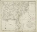
| Date: | 1851 |
|---|---|
| Description: | This map shows townships, villages, Indian villages, railroads, roads, mills, prairies, swamps, and canals. An inset map shows a plat of the copper distric... |
| Date: | 1961 |
|---|---|
| Description: | This map shows bays, lakes, and roads. Relief is shown by contours; depths are shown by isolines. Lake Michigan and Lake Winnebago are labeled. An explana... |

| Date: | 1942 |
|---|---|
| Description: | This pictorial bird's-eye-view map shows the United States of America with parts of Canada and Mexico. Landscape, trade, industry, points of interest, peop... |

| Date: | 1946 |
|---|---|
| Description: | This map shows scenes from America's history with names of historical events superimposed on a map of the United States. |
| Date: | 1792 |
|---|---|
| Description: | This map depicts the fixed boundaries by a peace treaty between the United States and the Spanish Dominions. |

| Date: | 1990 |
|---|---|
| Description: | This map shows the Minnesota Point, Wisconsin Point, Hog Island, Baker's Island, Connors Point, Blatnik Bridge, Superior Bay, Allouez Bay, the Nemadji Rive... |

| Date: | 2000 |
|---|---|
| Description: | This map shows national parks, county and state forests, Indian reservations, municipal land, private land, docks, boat access, camping, and points of inte... |

| Date: | 08 20 1951 |
|---|---|
| Description: | Elevated view through trees of the Lake Michigan shoreline. A birch tree with two trunks is in the foreground. |

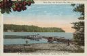
| Date: | 1980 |
|---|---|
| Description: | Aerial shot directly over Picnic Point. Boats are in the lake. Text on reverse reads: "Picnic Point — A peninsula of the University of Wisconsin campus jut... |

| Date: | |
|---|---|
| Description: | View of Picnic Point from Observatory Hill on the University of Wisconsin campus. Autumn color is in the trees. |

| Date: | |
|---|---|
| Description: | Hand-colored view of a small beach surrounded by boulders. Caption reads: "Beach at Picnic Point, Madison, Wis." |

| Date: | |
|---|---|
| Description: | View of Picnic Point and Lake Mendota from over the men's residence hall at the University of Wisconsin. |

| Date: | 1916 |
|---|---|
| Description: | Text on front reads: "North Point — Sheboygan, Wis." Elevated view of a Niagara limestone shelf of rock that rises above Lake Michigan. This rarely occurs ... |
| Date: | 1915 |
|---|---|
| Description: | Caption reads: "Sister Bay, near Sturgeon Bay, Wis." and "In Door County 'Cherryland,' the Nation's Largest Cherry Producer." Sister Bay from a rocky beach... |
If you didn't find the material you searched for, our Library Reference Staff can help.
Call our reference desk at 608-264-6535 or email us at: