 Filter: Categories of Wisconsin Historical Images
Filter: FORMAT_TYPE of prints, photomechanical
Filter: Subject of piers
Filter: Subject of industries
Filter: Categories of Wisconsin Historical Images
Filter: FORMAT_TYPE of prints, photomechanical
Filter: Subject of piers
Filter: Subject of industries

| Date: | 1886 |
|---|---|
| Description: | Bird's-eye view of Ashland, on the shores of Lake Superior, with insets of The Apostle Islands Chequamagon Bay & Ashland, and Distances from Ashland. |
| Date: | 1893 |
|---|---|
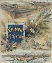
| Description: | Cover of an advertising catalog for William Deering & Company featuring chromolithograph illustrations of the Deering factory, the grain center of the worl... |

| Date: | 1885 |
|---|---|
| Description: | Bird's-eye view of Sheboygan, with inset of J.J. Volrath Manufacturing Company. |

| Date: | 1913 |
|---|---|
| Description: | Bird's-eye map of Superior. "The New Steel Center." |

| Date: | 1886 |
|---|---|
| Description: | Bird's-eye map of Washburn on Lake Superior. There is an inset of Washburn, Chequamagon and the Apostle Islands. |

| Date: | 1879 |
|---|---|
| Description: | Bird's-eye map of Two Rivers. |

| Date: | 1896 |
|---|---|
| Description: | Bird's-eye view of Washburn, with twenty vignettes around side, water in foreground with docks and lumber corral. Thirty-three locations identified in key ... |

| Date: | 1920 |
|---|---|
| Description: | Caption reads: "Mammoth Ore Docks, Ashland, Wis." A building and roads are in the foreground. Several ore ships can be seen. |
| Date: | 1912 |
|---|---|
| Description: | View across water toward buildings on the right, with men standing on a platform at the shoreline in front of a large building. Three more smaller building... |

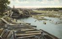
| Date: | 1902 |
|---|---|
| Description: | Two panoramic bird's-eye views of the Paine Lumber Company, including the general plant, sawmill, and lumber yards. Heading at the top says: Home of Wiscon... |
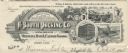
| Date: | |
|---|---|
| Description: | Memohead of the A. Booth Packing Company of Bayfield, Wisconsin, dealing in "Oval Brand Oysters, Fish & Canned Goods," with a three-quarter view of the com... |
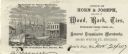
| Date: | |
|---|---|
| Description: | Letterhead of the Horn's Pier (Door County) office of Horn & Joseph, dealers in general merchandise, including "Wood, Bark, Ties, Telegraph Poles, Posts, &... |

| Date: | 1925 |
|---|---|
| Description: | Shows buildings, piers, winter and summer levels, and resort lands. Depths shown by isolines. Relief shown by contours. From the E.P. Sherry papers relatin... |
| Date: | 1910 |
|---|---|
| Description: | Colorized postcard of logs floating in river, looking east between falls and railroad bridge. In the upper right corner is a large number of logging pylons... |

| Date: | 1940 |
|---|---|
| Description: | Color enhanced postcard view of fisherman's shacks on the outlet of Logan's creek on the shore of Lake Michigan. |
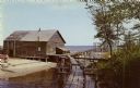
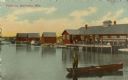
| Date: | 1958 |
|---|---|
| Description: | View towards a fishing dock on an outlet along the shoreline of Lake Michigan. |

| Date: | 06 1923 |
|---|---|
| Description: | Sanborn map of Ashland, which includes Chequamegon Bay. |

| Date: | 1902 |
|---|---|
| Description: | This map is a chart of Milwaukee Harbor that displays local streets, bridges, roads, railroads, public buildings, businesses, factories, dry docks, parks, ... |

| Date: | 1854 |
|---|---|
| Description: | This map shows streets, docks, warehouses, and piers near the harbor. Relief is shown by hachures and depths are shown by soundings and isolines. Lake Mich... |
If you didn't find the material you searched for, our Library Reference Staff can help.
Call our reference desk at 608-264-6535 or email us at:
