 Filter: Categories of Wisconsin Historical Images
Filter: FORMAT_TYPE of prints, photomechanical
Filter: Subject of piers
Filter: Categories of Wisconsin Historical Images
Filter: FORMAT_TYPE of prints, photomechanical
Filter: Subject of piers
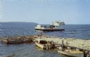
| Date: | 1961 |
|---|---|
| Description: | Color postcard view of the "Voyageur," a car and passenger ferry operating between mainland Door County and Washington Island. Two motorboats are moored on... |
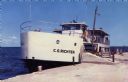
| Date: | 1950 |
|---|---|
| Description: | Color photographic postcard view of the "C.G. Richter" at the dock, a ferry operating between mainland Door County and Washington Island. |
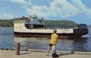
| Date: | 1950 |
|---|---|
| Description: | View from dock towards the Washington Island Ferry, "Eyrarbakki." There is a person sitting on a post on the dock. |

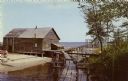
| Date: | 1940 |
|---|---|
| Description: | Color enhanced postcard view of fisherman's shacks on the outlet of Logan's creek on the shore of Lake Michigan. |
| Date: | 1958 |
|---|---|
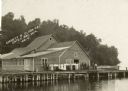
| Description: | View towards a fishing dock on an outlet along the shoreline of Lake Michigan. |

| Date: | 1910 |
|---|---|
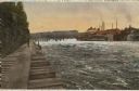
| Description: | Elevated view of the Eagle River dock, with excursion boats and a tug boat alongside two long piers in the foreground, and a steel frame bridge in the back... |
| Date: | 1910 |
|---|---|
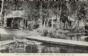
| Description: | View across water towards lakeside cabins among birch trees at the resort on Catfish Lake, east of Eagle River off of STH 70. There is a pier in the foregr... |
| Date: | 1908 |
|---|---|
| Description: | Colorized photograph of the dells, the dam and the paper mills on the Eau Claire River. A man is standing on a wooden pier along the shoreline on the left. |

| Date: | 06 1923 |
|---|---|
| Description: | Sanborn map of Ashland, which includes Chequamegon Bay. |
| Date: | |
|---|---|
| Description: | View across water towards a group of people, men, woman, and young girls and boys, posing on a pier in front of a building on the shoreline of Sister Bay. ... |

| Date: | 1902 |
|---|---|
| Description: | This map is a chart of Milwaukee Harbor that displays local streets, bridges, roads, railroads, public buildings, businesses, factories, dry docks, parks, ... |

| Date: | 07 19 1854 |
|---|---|
| Description: | This map shows the shore in 1844, 1850, and 1852, the length of and proposed additions to the pier. Relief is shown by hachures and depths are shown by sou... |

| Date: | 07 19 1854 |
|---|---|
| Description: | This hand-colored map shows the North and South Pier, the North Pier Bridge, the present Channel, and the Channel to be dredged. Lake Michigan and a light ... |

| Date: | 1857 |
|---|---|
| Description: | This map with north oriented toward the lower left shows the United States North and South Piers. Lake shores from 1855, 1856, and 1857 are labeled. Depths... |

| Date: | 09 1853 |
|---|---|
| Description: | This map shows streets, docks, warehouses, and piers near the harbor. The Manitowoc River and Lake Michigan are labeled. Depths are indicated by soundings ... |

| Date: | 1854 |
|---|---|
| Description: | This map shows streets, docks, warehouses, and piers near the harbor. Relief is shown by hachures and depths are shown by soundings and isolines. Lake Mich... |

| Date: | 1856 |
|---|---|
| Description: | This map shows streets, piers, and wharves. Lake Michigan, the Manitowoc River, and select buildings are labeled. Relief is shown by hachures and sounding... |

| Date: | 1865 |
|---|---|
| Description: | This map shows the river shore and piers. Lake Michigan is labeled. Depths are shown by soundings and isolines. The bottom margin includes notes on soundi... |

| Date: | 1874 |
|---|---|
| Description: | This map shows piers, streets, the Manitowoc River and shore lines of 1856, 1869, 1873 and 1874. The top margin reads; "Soundings taken 1974." Written in i... |

| Date: | 10 1853 |
|---|---|
| Description: | This map shows warehouses and proposed extensions of piers. "Note: The soundings are in feet and tenths." The upper left margin reads: "Senate Ex. Doc. No.... |
If you didn't find the material you searched for, our Library Reference Staff can help.
Call our reference desk at 608-264-6535 or email us at: