 Filter: Categories of Wisconsin Historical Images
Filter: FORMAT_TYPE of prints, photomechanical
Filter: Subject of public utilities
Filter: Categories of Wisconsin Historical Images
Filter: FORMAT_TYPE of prints, photomechanical
Filter: Subject of public utilities
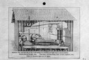
| Date: | 1882 |
|---|---|
| Description: | Cutaway view of the building that housed the first electrical station created to distribute incandescent light electricity. |
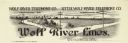
| Date: | |
|---|---|
| Description: | Letterhead of Wolf River Lines, a telephone company in Weyauwega, Wisconsin, with telephone poles and wires spanning a river with silhouettes of buildings ... |

| Date: | |
|---|---|
| Description: | Letterhead of the Farmers' New Era Telephone Company of Hebron, Illinois, with a female switchboard operator wearing headphones sitting near a window with ... |
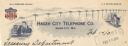
| Date: | |
|---|---|
| Description: | Letterhead of the Hager City Telephone Company of Hager City, Wisconsin, with a line of telephone poles and wires connecting a man in a business suit sitti... |

| Date: | |
|---|---|
| Description: | Letterhead of the Milwaukee Electric Railway and Light Company, with a three-quarter view of a man driving an electric cable car marked "State St." under a... |

| Date: | 1903 |
|---|---|
| Description: | This map is ink on printed paper reading: "standard profile plate." "Surveyed Oct. 15, platted Dec. 15, 1903 ; surveyed May 9, platted Dec. 9." |
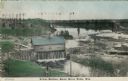
| Date: | 1908 |
|---|---|
| Description: | Colorized photographic postcard of an elevated view of the power station next to the river. A bridge is in the background. Caption reads: "Power Station, B... |

| Date: | 1888 |
|---|---|
| Description: | This map has relief shown by hachures and features inset maps of a plat of E.D. Clinton and Blackwell’s add’n to the City of La Crosse. Wards (1-10) shaded... |

| Date: | 1894 |
|---|---|
| Description: | This map shows lot and block numbers, railroads, street car tracks, sewers, water mains, gas mains, paved streets, land owned by the Land & River Improveme... |

| Date: | 1973 |
|---|---|
| Description: | This map is 1 of 7 and includes a location map and township diagram in the margins. The map includes a key of land type: Residential (yellow), Commercial (... |

| Date: | 1973 |
|---|---|
| Description: | This map is 2 of 7 and includes a location map and township diagram in the bottom margin. The map includes a key of land type: Residential (yellow), Commer... |

| Date: | 1973 |
|---|---|
| Description: | This map is 3 of 7 and includes a location map and township diagram in the margins. The map includes a key of land type: Residential (yellow), Commercial (... |

| Date: | 1973 |
|---|---|
| Description: | This map is 4 of 7 and includes a location map and township diagram in the left margin. The map includes a key of land type: Residential (yellow), Commerci... |

| Date: | 1973 |
|---|---|
| Description: | This map is 5 of 7 and includes a location map and township diagram in the left margin. The map includes a key of land type: Residential (yellow), Commerci... |

| Date: | 1973 |
|---|---|
| Description: | This map is 6 of 7 and includes a location map and township diagram in the bottom margin. The map includes a key of land type: Residential (yellow), Commer... |

| Date: | 1973 |
|---|---|
| Description: | This map is 7 of 7 and includes a location map and township diagram in the left margin. The map includes a key of land type: Residential (yellow), Commerci... |

| Date: | 01 07 1922 |
|---|---|
| Description: | Text on front reads: "Dam and Electric Power Plant, Watertown, Wis." The Watertown Electric Company Power Plant #1 was built in 1909 of cream brick. Rollin... |
If you didn't find the material you searched for, our Library Reference Staff can help.
Call our reference desk at 608-264-6535 or email us at: