 Filter: Categories of Wisconsin Historical Images
Filter: FORMAT_TYPE of prints, photomechanical
Filter: Subject of railroad stations
Filter: Subject of land
Filter: Categories of Wisconsin Historical Images
Filter: FORMAT_TYPE of prints, photomechanical
Filter: Subject of railroad stations
Filter: Subject of land

| Date: | 1915 |
|---|---|
| Description: | Elevated view of the St. Croix River, Northwest Railroad, bridge, and part of the town of Hudson. Caption reads: "Hudson, Wis. Bird's Eye View, showing St.... |

| Date: | |
|---|---|
| Description: | Map of the City of the First Lake. Drawn by J. Judson, Greene & McGowran litho. Scale: 200 ft. to 1 inch. "Paper city located near Lake Kegonsa." |
| Date: | |
|---|---|
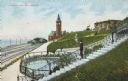
| Description: | Train station in the distance, with a man standing in the foreground on steps leading down to the lake, near a fenced-in pond. On the left are railroad tra... |
| Date: | 1910 |
|---|---|
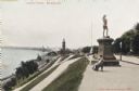
| Description: | View along top of hill in the park toward a woman and child sitting on a bench near the monument. At the bottom of the hill on the left are railroad tracks... |
| Date: | 1910 |
|---|---|
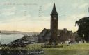
| Description: | Chicago & Northwestern Railway Depot, with train shed and clock tower. In the foreground is a landscaped area with flowers. In the background is Lake Mich... |

| Date: | 1863 |
|---|---|
| Description: | A map of Illinois showing all railroads, stations, and towns. |

| Date: | 1896 |
|---|---|
| Description: | A map of the Chain-O-Lakes in Waupaca, including Indian trails. The path of the Waupaca Electric Railway from the Grand View Hotel to the Wisconsin Central... |

| Date: | 1930 |
|---|---|
| Description: | Pictorial map of Glacier National Park, Montana and Waterton Lakes National Park, Alberta. Illustrated by Joe Scheurle, it depicts white people, American ... |

| Date: | 1800 |
|---|---|
| Description: | Shows plat of town, land ownership by name, local streets, courthouses, churches, hotels, mills, railroads, railroad stations, lakes, and rivers. Includes ... |

| Date: | 1852 |
|---|---|
| Description: | Map created between 1852 and 1867 shows numbered lots, labelled roads, the "Centre Line of LaCrosse & Milwaukee R.R." railroad, and a station house. Roads ... |

| Date: | 1918 |
|---|---|
| Description: | This map shows railroads, street car lines, wards, private claims, parks, railroad yards and depots, and cemeteries. The map is oriented with north to uppe... |

| Date: | 1868 |
|---|---|
| Description: | This map is ink on tracing cloth and shows lot and block numbers, depot, railroads and side tracks, and streets in sections 24 and 25, T.11, R.16E. The map... |
If you didn't find the material you searched for, our Library Reference Staff can help.
Call our reference desk at 608-264-6535 or email us at: