 Filter: Categories of Wisconsin Historical Images
Filter: FORMAT_TYPE of prints, photomechanical
Filter: Subject of railroad stations
Filter: Subject of roads
Filter: Categories of Wisconsin Historical Images
Filter: FORMAT_TYPE of prints, photomechanical
Filter: Subject of railroad stations
Filter: Subject of roads
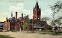
| Date: | 1908 |
|---|---|
| Description: | Union Depot with clock tower. The railroad station with clock tower is behind a park. Horse-drawn vehicles are near the entrance. Caption reads: "Union Dep... |
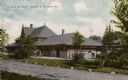
| Date: | 1905 |
|---|---|
| Description: | Chicago & Northwestern Railway Passenger Station. Side view with two horses standing next to station. Caption reads: "C. & N. W. Depot, Neenah & Menasha, W... |

| Date: | |
|---|---|
| Description: | Map of the City of the First Lake. Drawn by J. Judson, Greene & McGowran litho. Scale: 200 ft. to 1 inch. "Paper city located near Lake Kegonsa." |
| Date: | 1910 |
|---|---|
| Description: | View of the Chicago, Milwaukee, & St. Paul Railway passenger station at W. Everett Street between N. 3rd and N. 4th Streets. View is from the across the st... |

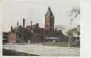
| Date: | |
|---|---|
| Description: | Union Depot with clock tower. Railroad station on left side, with clock tower. Park area on right with horse-drawn vehicles near the entrance. Caption read... |
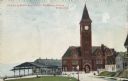
| Date: | 1904 |
|---|---|
| Description: | The station with the clock tower is on the right, and the tracks and train shed are on the left. Pedestrians are on the lawn nearby, and houses are on the ... |
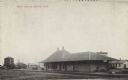
| Date: | 05 14 1909 |
|---|---|
| Description: | Black and white postcard view of the Soo Line railroad depot. Caption reads: "'SOO' Depot, Bruce, Wis." |

| Date: | |
|---|---|
| Description: | A map that shows the Wisconsin Central Railway land grant lands for sale by the Soo Line, the Chicago, Milwaukee, and St. Paul Railway. Town sections, lak... |

| Date: | 1886 |
|---|---|
| Description: | A hand-colored map of Milwaukee County, Wisconsin that shows the township and range system, sections, towns, roads, railroads and rail stations, cities and... |

| Date: | 1891 |
|---|---|
| Description: | A hand-colored map of Milwaukee County, Wisconsin that shows the township and range system, sections, towns, roads, railroads and rail stations, cities and... |

| Date: | 1902 |
|---|---|
| Description: | A map of Milwaukee County, Wisconsin that shows the township and range system, sections, towns, roads, railroads and rail stations, cities and villages, po... |

| Date: | 1968 |
|---|---|
| Description: | A tourist map of Milwaukee County and of downtown Milwaukee. The Map of Milwaukee County identifies the location of some of the points of interests in the ... |

| Date: | 1899 |
|---|---|
| Description: | This 1899 map of Douglas County, Wisconsin, shows the township and range grid, towns, sections, cities, villages and railroad stations, mines, roads, railr... |

| Date: | 1898 |
|---|---|
| Description: | Map showing the contour depths of the lakes in northwestern Waukesha County, Wisconsin. Roads, railroads, depots, churches, schools, and hotels in the area... |

| Date: | 1903 |
|---|---|
| Description: | Map shows railroads, roads, street car lines, schools, churches, cemeteries, town halls, and railroad stations. Includes inset lists of: Population of Milw... |

| Date: | 1852 |
|---|---|
| Description: | Map created between 1852 and 1867 shows numbered lots, labelled roads, the "Centre Line of LaCrosse & Milwaukee R.R." railroad, and a station house. Roads ... |
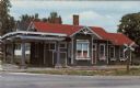
| Date: | |
|---|---|
| Description: | Text on reverse reads: "Fox Lake Historical Society Museum, Inc. Corner Cordelia & College Avenue Fox Lake, Wisconsin. Member State of Wisconsin Historical... |
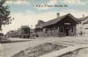
| Date: | 1918 |
|---|---|
| Description: | View from road towards the Mayville train depot, with a passenger train on the left set of two railroad tracks. Caption reads: "C.M. & St. Paul Depot, Mayv... |
If you didn't find the material you searched for, our Library Reference Staff can help.
Call our reference desk at 608-264-6535 or email us at: