 Filter: Categories of Wisconsin Historical Images
Filter: FORMAT_TYPE of prints, photomechanical
Filter: Subject of railroad stations
Filter: Subject of water
Filter: Categories of Wisconsin Historical Images
Filter: FORMAT_TYPE of prints, photomechanical
Filter: Subject of railroad stations
Filter: Subject of water

| Date: | 1915 |
|---|---|
| Description: | Elevated view of the St. Croix River, Northwest Railroad, bridge, and part of the town of Hudson. Caption reads: "Hudson, Wis. Bird's Eye View, showing St.... |
| Date: | 1905 |
|---|---|
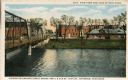
| Description: | View with the Milwaukee Street Bridge on the left, and on the opposite shoreline is the Chicago & Northwestern Railway Station. Caption at top reads: "View... |

| Date: | |
|---|---|
| Description: | Map of the City of the First Lake. Drawn by J. Judson, Greene & McGowran litho. Scale: 200 ft. to 1 inch. "Paper city located near Lake Kegonsa." |

| Date: | 1905 |
|---|---|
| Description: | Clockwise from upper left images include: Cutters Point, Long Lake, Wis.; M.E. Church, New Auburn, Wis.; Farmers Store, New Auburn, Wis.; Public School, Ne... |
| Date: | |
|---|---|
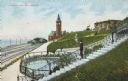
| Description: | Train station in the distance, with a man standing in the foreground on steps leading down to the lake, near a fenced-in pond. On the left are railroad tra... |
| Date: | 1910 |
|---|---|
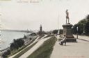
| Description: | View along top of hill in the park toward a woman and child sitting on a bench near the monument. At the bottom of the hill on the left are railroad tracks... |
| Date: | 1910 |
|---|---|
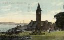
| Description: | Chicago & Northwestern Railway Depot, with train shed and clock tower. In the foreground is a landscaped area with flowers. In the background is Lake Mich... |
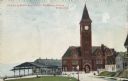
| Date: | 1904 |
|---|---|
| Description: | The station with the clock tower is on the right, and the tracks and train shed are on the left. Pedestrians are on the lawn nearby, and houses are on the ... |

| Date: | 1863 |
|---|---|
| Description: | A map of Illinois showing all railroads, stations, and towns. |

| Date: | 1896 |
|---|---|
| Description: | A map of the Chain-O-Lakes in Waupaca, including Indian trails. The path of the Waupaca Electric Railway from the Grand View Hotel to the Wisconsin Central... |

| Date: | 1930 |
|---|---|
| Description: | Pictorial map of Glacier National Park, Montana and Waterton Lakes National Park, Alberta. Illustrated by Joe Scheurle, it depicts white people, American ... |

| Date: | 1936 |
|---|---|
| Description: | An elevated view of Milwaukee Harbor with railroad station looking towards Lake Michigan. |

| Date: | 1866 |
|---|---|
| Description: | This map shows the railroads both completed and under construction in southern Wisconsin, Iowa, Illinois, and Missouri. Railroad terminals, junctions, and ... |

| Date: | 1867 |
|---|---|
| Description: | This map, which includes eastern Iowa, northern Illinois and the western portion of Michigan's Upper peninsula, shows the township survey grid and identifi... |

| Date: | |
|---|---|
| Description: | A map that shows the Wisconsin Central Railway land grant lands for sale by the Soo Line, the Chicago, Milwaukee, and St. Paul Railway. Town sections, lak... |

| Date: | 1886 |
|---|---|
| Description: | A hand-colored map of Milwaukee County, Wisconsin that shows the township and range system, sections, towns, roads, railroads and rail stations, cities and... |

| Date: | 1891 |
|---|---|
| Description: | A hand-colored map of Milwaukee County, Wisconsin that shows the township and range system, sections, towns, roads, railroads and rail stations, cities and... |

| Date: | 1902 |
|---|---|
| Description: | A map of Milwaukee County, Wisconsin that shows the township and range system, sections, towns, roads, railroads and rail stations, cities and villages, po... |

| Date: | 1968 |
|---|---|
| Description: | A tourist map of Milwaukee County and of downtown Milwaukee. The Map of Milwaukee County identifies the location of some of the points of interests in the ... |

| Date: | 1898 |
|---|---|
| Description: | Map showing the contour depths of the lakes in northwestern Waukesha County, Wisconsin. Roads, railroads, depots, churches, schools, and hotels in the area... |
If you didn't find the material you searched for, our Library Reference Staff can help.
Call our reference desk at 608-264-6535 or email us at: