 Filter: Categories of Wisconsin Historical Images
Filter: FORMAT_TYPE of prints, photomechanical
Filter: Subject of railroad tracks
Filter: Categories of Wisconsin Historical Images
Filter: FORMAT_TYPE of prints, photomechanical
Filter: Subject of railroad tracks

| Date: | |
|---|---|
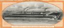
| Description: | Colorized postcard of the horseshoe curve of railroad tracks. Elevated view of the railroad tracks with train snaking past a farmhouse and a bridge suspend... |
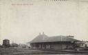
| Date: | 05 14 1909 |
|---|---|
| Description: | Black and white postcard view of the Soo Line railroad depot. Caption reads: "'SOO' Depot, Bruce, Wis." |
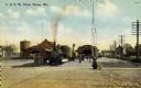
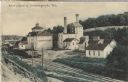
| Date: | 1910 |
|---|---|
| Description: | View of the Chicago & Northwestern Railroad depot. A train rests at the stop while commuters wait to board from the platform. There is a horse to the right... |
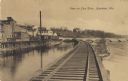
| Date: | |
|---|---|
| Description: | View of the Fox River near Appleton from an elevated railroad track. The fourth lock is located to the extreme right crossing the river. Railroad cars and ... |
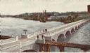
| Date: | |
|---|---|
| Description: | Colorized postcard of an elevated view of the white brick John Street Bridge spanning the Fox River. A set of railroad tracks crosses over a section of the... |
| Date: | |
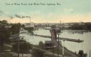
|---|---|
| Description: | Elevated view of factories and railway line along the Fox River. Caption reads: "View of Water Power from Wests Park, Appleton, Wis." |

| Date: | |
|---|---|
| Description: | Four views of Ashland, including Ellis Avenue, the Chicago and North Western Depot, Northern Pacific and Omaha trains and West Second Street. |
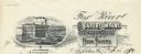
| Date: | |
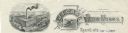
|---|---|
| Description: | Memohead of the J.I. Case Plow Works of Racine, Wisconsin, with an elevated view of the company plant and a smaller scene set on a scroll of a man driving ... |
| Date: | |
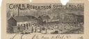
|---|---|
| Description: | Letterhead of the Cohn & Robertson Granite Manufacturing Company of Granite Heights and Wausau, Wisconsin, with a view of workers loading a C.M.&St.P. rail... |

| Date: | 1860 |
|---|---|
| Description: | This colored map shows railroad lines east of the Mississippi as well as in the states bordering the Mississippi River. The Great Lakes and Gulf of Mexico ... |
| Date: | |
|---|---|
| Description: | Letterhead of the Post Office in Cazenovia, Wisconsin. On the left is an eagle resting on a pile of U.S. Mail bags. On the right is an image of a railroad ... |
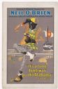
| Date: | 1915 |
|---|---|
| Description: | Color lithograph poster on paper. Across the top it reads: "Oscar F. Hodge presents," underneath, in larger blue letters is: "Neil O'Brien." Below this: "a... |

| Date: | 1855 |
|---|---|
| Description: | Drawn around 1855, this map shows the placement of railroad tracks in southern Wisconsin and northern Illinois connecting Milwaukee, Prairie du Chien, Gale... |
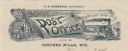
| Date: | |
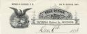
|---|---|
| Description: | Letterhead of the Post Office in Porters Mills, Wisconsin, with a man putting mail into post office boxes, a padlocked mail bag that serves as a signboard ... |
| Date: | |
|---|---|
| Description: | Letterhead of the Fox River Paper Company of Appleton, Wisconsin, with a three-quarter view of the company building and a hanging roll of paper that incorp... |
| Date: | 1910 |
|---|---|
| Description: | Postcard of the Stork Brewery facilities. The image includes the brewery buildings along a hillside and railroad tracks in the foreground. There is a sign ... |
| Date: | 1920 |
|---|---|
| Description: | Back cover of a brochure advertising Moline Universal tractors. The text beneath an illustration of the Moline Plow Company factory reads: "The Largest Tra... |

| Date: | 1868 |
|---|---|
| Description: | Prepared for the State Board of Emigration in 1868, this map shows county boundaries, some cities, and completed and projected railroads. |

| Date: | 1871 |
|---|---|
| Description: | Map of Wisconsin and portions of Minnesota, Michigan, Illinois and Iowa show the major railway tracks and their connections in red and blue ink. Lakes, riv... |

| Date: | 1857 |
|---|---|
| Description: | This hand-colored map shows southern Wisconsin and northern Illinois and indicates county boundaries, larger cities, and some drainage. The line was charte... |
If you didn't find the material you searched for, our Library Reference Staff can help.
Call our reference desk at 608-264-6535 or email us at: