 Filter: Categories of Wisconsin Historical Images
Filter: FORMAT_TYPE of prints, photomechanical
Filter: Subject of railroad trains
Filter: Subject of rivers
Filter: Categories of Wisconsin Historical Images
Filter: FORMAT_TYPE of prints, photomechanical
Filter: Subject of railroad trains
Filter: Subject of rivers

| Date: | 1870 |
|---|---|
| Description: | Bird's-eye map of Kilbourn City, now known as Wisconsin Dells. Kilbourn City was platted in the 1850s and received a boost when the La Crosse and Milwaukee... |

| Date: | 1875 |
|---|---|
| Description: | Bird's-eye map of Mazomanie. |
| Date: | |
|---|---|
| Description: | The railroad bridge over the Rock River. |

| Date: | 1892 |
|---|---|
| Description: | Bird's-eye view of the Columbian Exposition pavilions from the vantage point of Lake Michigan. Included is an inset of the Union Passenger Station (now Uni... |
| Date: | 1905 |
|---|---|
| Description: | Elevated view of the railroad station looking west. A bridge over the river is in the foreground, and a large water tower is across the railroad tracks on ... |

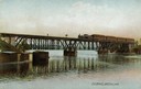
| Date: | 1860 |
|---|---|
| Description: | View of the Rock River with a train on a railroad bridge in the foreground, and the town in the distance. Pedestrians are walking along a path on the left ... |
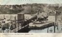
| Date: | 1880 |
|---|---|
| Description: | View across river toward the malt house. In the background is the south side brewery of the same company. There are two steamboats, one large, one small. ... |
| Date: | 1901 |
|---|---|
| Description: | Lithographed poster depicting an elevated view of the Warder, Bushnell, and Glessner factory and surrounding area. Text in the upper left corner reads, "Ch... |

| Date: | 1878 |
|---|---|
| Description: | Illustrated map of Crawford County. On the bottom right is an inset of a group of people near a train on a railroad track. |

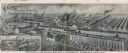
| Date: | 1902 |
|---|---|
| Description: | Two panoramic bird's-eye views of the Paine Lumber Company, including the general plant, sawmill, and lumber yards. Heading at the top says: Home of Wiscon... |

| Date: | |
|---|---|
| Description: | Colorized postcard of the horseshoe curve of railroad tracks. Elevated view of the railroad tracks with train snaking past a farmhouse and a bridge suspend... |

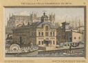
| Date: | |
|---|---|
| Description: | Letterhead of the Phillip Best Brewing Company of Milwaukee, Wisconsin, with three separate proscenium views of the Empire Brewery, the South Side Brewery,... |
| Date: | |
|---|---|
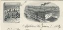
| Description: | Letterhead of the Atlas Paper Company of Appleton, Wisconsin, a paper company established in 1878. On the left is a scroll embellished with a spray of flow... |
| Date: | |
|---|---|
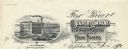
| Description: | Letterhead of the Fox River Paper Company of Appleton, Wisconsin, with a three-quarter view of the company building and a hanging roll of paper that incorp... |
| Date: | 1901 |
|---|---|
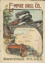
| Description: | Catalog cover with the title: "The Three Greatest Empires," features an illustration of an Empire Drill in the foreground, and in the background a train tr... |
| Date: | 1880 |
|---|---|
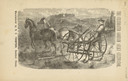
| Description: | Front page of booklet with an engraving of a man with a team of two horses in a field with the "Celebrated Gorham Sulky Cultivator." |

| Date: | 1910 |
|---|---|
| Description: | Aerial view along river toward Darlington. Caption reads: "Bird's-Eye View, Darlington, Wis." |
| Date: | 1910 |
|---|---|
| Description: | Enhanced photographic postcard of a lattice deck truss railroad high bridge and paper mill on the Chippewa River. The bridge was built in 1880 by the Chica... |

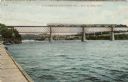
| Date: | 1913 |
|---|---|
| Description: | View of a train crossing a railroad bridge over the Fox River. Rowboats are in the river and docked at a pier in the foreground. Caption reads: "C. & N. W.... |

| Date: | 1952 |
|---|---|
| Description: | This colored map shows the entire state, along with counties in states bordering Wisconsin. There is a key to "Wisconsin Railroads," with initials identify... |
If you didn't find the material you searched for, our Library Reference Staff can help.
Call our reference desk at 608-264-6535 or email us at: