 Filter: Categories of Wisconsin Historical Images
Filter: FORMAT_TYPE of prints, photomechanical
Filter: Subject of road construction industry
Filter: Subject of land
Filter: Categories of Wisconsin Historical Images
Filter: FORMAT_TYPE of prints, photomechanical
Filter: Subject of road construction industry
Filter: Subject of land

| Date: | 1909 |
|---|---|
| Description: | [Lithography] by Poole Bros. Contains descriptive information. Short jaunts for busy people to nearby resorts in Illinois and Wisconsin. |
| Date: | 1920 |
|---|---|
| Description: | Front cover of a booklet advertising the Russell Road Roller. The cover features an illustration of the machinery at work along a rural road and text that ... |

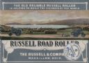
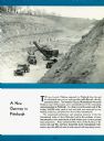
| Date: | 1931 |
|---|---|
| Description: | Page from an advertising brochure for International trucks. An International truck ascends a hillside during the widening of the Pennsylvania roadbed betwe... |
| Date: | 1931 |
|---|---|
| Description: | Page from an advertising brochure for International trucks. International trucks are used on a construction site during the building of the George Westingh... |

| Date: | 1959 |
|---|---|
| Description: | International trucks parked near a bridge construction site. |

| Date: | 1976 |
|---|---|
| Description: | An 1876 reprinted map of the Township of Franklin, Milwaukee County, Wisconsin, that shows the land ownership and sectioning of the town, as well as the ro... |

| Date: | 1896 |
|---|---|
| Description: | This 1896 map shows the township and range system, sections, cities and villages, railroads, roads, vacant land and land sold by the Wisconsin Central Rail... |
If you didn't find the material you searched for, our Library Reference Staff can help.
Call our reference desk at 608-264-6535 or email us at: