 Filter: Categories of Wisconsin Historical Images
Filter: FORMAT_TYPE of prints, photomechanical
Filter: Subject of sawmills
Filter: Creator Name of Unknown
Filter: Categories of Wisconsin Historical Images
Filter: FORMAT_TYPE of prints, photomechanical
Filter: Subject of sawmills
Filter: Creator Name of Unknown
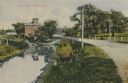
| Date: | 1910 |
|---|---|
| Description: | Distant view of the mill, with a stream leading to it, and a road paralleling the stream on the right. Caption reads: "The Old Mill, Delavan, Wis." |
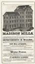
| Date: | 1851 |
|---|---|
| Description: | Engraving of the five-story tall mill erected at the outlet of the Yahara Creek by Leonard J. Farwell. This engraving appears in Statistics of Dane County,... |

| Date: | |
|---|---|
| Description: | A composite image of three photographs of sawmills and a saw graphic. The sawmills pictured are R.W. Merryman and Co.'s Mill (top), Sawyer & Goodman Co.'s ... |

| Date: | |
|---|---|
| Description: | A composite image of three photographs of sawmills with decorative graphics. The mills are N. Ludington Co.'s Old White Mill (top), the H. Witbeck Co.'s Mi... |

| Date: | 1902 |
|---|---|
| Description: | Two panoramic bird's-eye views of the Paine Lumber Company, including the general plant, sawmill, and lumber yards. Heading at the top says: Home of Wiscon... |

| Date: | 1914 |
|---|---|
| Description: | This map is a photostat copy from the original 1829 map in the War Department. The map shows location of Fort Howard, lots, land claims of Jacques Porlier ... |

| Date: | 1909 |
|---|---|
| Description: | A map of Langlade County, Wisconsin that shows townships and ranges, towns, cities and villages, wagon roads, churches, schools, sawmills, town halls, chee... |

| Date: | 1909 |
|---|---|
| Description: | This 1909 map of Taylor County, Wisconsin, shows the township and range grid, towns, sections, cities and villages, settlers houses, schools, churches, saw... |

| Date: | 1870 |
|---|---|
| Description: | This map is ink and color on tracing cloth and shows Iron Ridge, the hotel and saw mill at Iron Ridge Village, Milwaukee & St. Paul Railway, plank road, an... |

| Date: | 1891 |
|---|---|
| Description: | This map shows vacant Southwick & Sellers lands, settlers' houses, Goodland Co. land, schools, churches, saw mills, roads, and railroads. A key in the uppe... |

| Date: | 1909 |
|---|---|
| Description: | This map shows vacant Wisconsin Central Ry. lands, settlers houses, lands sold by Wisconsin Central Ry., schools, churches, saw mills, and roads; also show... |
If you didn't find the material you searched for, our Library Reference Staff can help.
Call our reference desk at 608-264-6535 or email us at: