 Filter: Categories of Wisconsin Historical Images
Filter: FORMAT_TYPE of prints, photomechanical
Filter: Subject of sawmills
Filter: Categories of Wisconsin Historical Images
Filter: FORMAT_TYPE of prints, photomechanical
Filter: Subject of sawmills

| Date: | 1900 |
|---|---|
| Description: | This photostat of a manuscript map originally drawn in 1829 shows landownership, buildings, including Fort Howard and U.S. sawmill, swamps, public barns an... |

| Date: | 1900 |
|---|---|
| Description: | This photostat map shows private claim owners, natural meadows, roads, saw and grist mills, and Fort Howard. The upper right corner includes annotations an... |

| Date: | 1900 |
|---|---|
| Description: | This photostat map was probably originally created in 1835 and shows in addition to private claims, mills, roads, and trails. Green Bay and the Fox River a... |

| Date: | 1912 |
|---|---|
| Description: | This map shows land for sale by the Rusk Farm Company. Caption reads, "Look carefully at the map. Notice the thickly settled country on all sides of our la... |

| Date: | 1866 |
|---|---|
| Description: | A colorful map of Gilpin County, the central gold region of Colorado, surveyed by Charles W. Morse and George Hill. |
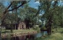
| Date: | |
|---|---|
| Description: | Ektachrome postcard of the blacksmith shop next to a stream. Text on reverse reads: "The Blacksmith Shop was Sylvanus Wade's first venture in Greenbush.... |

| Date: | 1901 |
|---|---|
| Description: | A Sanborn map of Tomahawk featuring the Bay Mill Company's lumber yard. |

| Date: | 1950 |
|---|---|
| Description: | A man is driving an International A tractor. Subject: "Material Handling — Int. Super A." Information with photograph reads: "An International A tractor pu... |

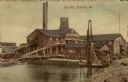
| Date: | |
|---|---|
| Description: | View across water towards a mill on the waterfront. Caption reads: "Park Mills, Marinette, Wis." |
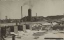
| Date: | 1909 |
|---|---|
| Description: | View of a sawmill next to a river. Conveyor ramps are leading into the building. Caption reads: "Saw Mill, Marinette, Wis." |
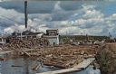
| Date: | 1972 |
|---|---|
| Description: | View of a log jam on the Wolf River next to a saw mill. Caption on back reads: "first built in 1908 . . . 20,000,000 feet lumber cut a year . . . largest i... |
| Date: | 1909 |
|---|---|
| Description: | Text on front reads: "Brooks & Ross Sawmill & Dam, Schofield, Wis. 1909." The dam and millpond with the sawmill behind it. There are multiple buildings wit... |
If you didn't find the material you searched for, our Library Reference Staff can help.
Call our reference desk at 608-264-6535 or email us at:

