 Filter: Categories of Wisconsin Historical Images
Filter: FORMAT_TYPE of prints, photomechanical
Filter: Subject of shipping
Filter: Categories of Wisconsin Historical Images
Filter: FORMAT_TYPE of prints, photomechanical
Filter: Subject of shipping

| Date: | 1889 |
|---|---|
| Description: | This map shows lot and block numbers, established dock lines, docks, slips, railroads, and streets of West Superior in 1889. |

| Date: | 1902 |
|---|---|
| Description: | This map is a chart of Milwaukee Harbor that displays local streets, bridges, roads, railroads, public buildings, businesses, factories, dry docks, parks, ... |

| Date: | 1923 |
|---|---|
| Description: | This map includes an explanation that reads: "This chart shows the movement of barley on the Great Lakes, St. Lawrence River, and New York State Barge Cana... |

| Date: | 1923 |
|---|---|
| Description: | This map includes an explanation that reads: "This chart shows the movement of corn on the Great Lakes, St. Lawrence River, and New York State Barge Canal ... |

| Date: | 1923 |
|---|---|
| Description: | This map includes an explanation that reads: "This chart shows the easterly movement of flaxseed on the Great Lakes, St. Lawrence River, and New York State... |

| Date: | 1923 |
|---|---|
| Description: | This map includes an explanation that reads: "This chart shows the movement of grain on the Great Lakes, St. Lawrence River, and New York State Barge Canal... |

| Date: | 1923 |
|---|---|
| Description: | This map includes an explanation that reads: "This chart shows the movement of rye on the Great Lakes, St. Lawrence River, and New York State Barge Canal d... |

| Date: | 1923 |
|---|---|
| Description: | This map includes an explanation that reads: "This chart shows the movement of wheat on the Great Lakes, St. Lawrence River, and New York State Barge Canal... |

| Date: | 04 1926 |
|---|---|
| Description: | This blueprint mostly shows various numbers within the canal and bay. Lake Michigan and Harobor of Refuge are shown along the far right side. Near the harb... |

| Date: | 1960 |
|---|---|
| Description: | This dot density map shows the number of shipments in 1952 throughout Wisconsin and to other United States destinations from Neillsville. Mellen, Cable, Bl... |

| Date: | 1858 |
|---|---|
| Description: | This map shows the proposed railways of the Tomah & Lake St. Croix Railroad (from Tomah to Hudson) and the St. Croix & Lake Superior Railroad (from Hudson ... |

| Date: | 1938 |
|---|---|
| Description: | Inside spread of "At Home Abroad" brochure. The title reads: "A World-wide Sales and Service Organization." Features a map of the continents of the world. ... |

| Date: | |
|---|---|
| Description: | 1881 version of the Coat of Arms of the State of Wisconsin. |

| Date: | 1938 |
|---|---|
| Description: | Advertising Proof. Title reads: "Bought the FIRST Cab-over-Engine INTERNATIONAL, They NOW own 290." The triple diamond logo is on the right just above the ... |
| Date: | 1898 |
|---|---|
| Description: | Text at top reads: "Forty Harvest Seasons" with "13,852 Carloads in 12 months handled in the Great Deering Harvester Works." Includes an illustration of th... |
| Date: | 1952 |
|---|---|
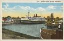
| Description: | Text on front reads: "Harbor Scene, Racine Wisconsin." A large ship is docked in Racine's harbor, with another ship and harbor facilities. |
| Date: | 10 17 1906 |
|---|---|
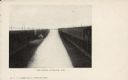
| Description: | Text on front reads: "Harbor View - Sheboygan, Wis." A lake freighter, or "laker" is docked at the harbor. |
| Date: | 1904 |
|---|---|
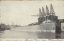
| Description: | Text on front reads: "Ore Docks, Superior, Wis." Elevated view of an ore carrying ship that is within the ore docks on Lake Superior. |

| Date: | 03 23 1915 |
|---|---|
| Description: | Text on front reads: "Steamship William E. Corey, entering Duluth and Superior Harbor, Wis." A steamship entering the harbor under the Aerial Lift Bridge, ... |
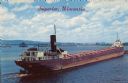
| Date: | 1936 |
|---|---|
| Description: | Text on front reads: "Superior, Wisconsin." On reverse: "Harry Wm. Hosford. This view was taken from the Arrowhead Bridge. It just unloaded its cargo of co... |
If you didn't find the material you searched for, our Library Reference Staff can help.
Call our reference desk at 608-264-6535 or email us at: