 Filter: Categories of Wisconsin Historical Images
Filter: FORMAT_TYPE of prints, photomechanical
Filter: Subject of st. croix river (wis. and minn.)
Filter: Categories of Wisconsin Historical Images
Filter: FORMAT_TYPE of prints, photomechanical
Filter: Subject of st. croix river (wis. and minn.)
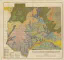
| Date: | 1911 |
|---|---|
| Description: | This map shows soil types of towns and counties. A key of 14 soil types is included. The top left margin reads: "Wisconsin Geological and Natural History S... |
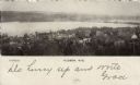
| Date: | 1906 |
|---|---|
| Description: | Elevated view of Hudson and the St. Croix River. The Interstate Bridge is spanning the river. Caption reads: "Hudson, Wis." |

| Date: | 1927 |
|---|---|
| Description: | Elevated view of the wagon bridge spanning the St. Croix River. An excursion boat is passing underneath the bridge. Hudson is on the far bank. Caption read... |

| Date: | 1907 |
|---|---|
| Description: | Text on front reads: "The Birches. Inter-State Park. Taylors Falls Minn." Taylors Falls is crossed out and "On Wisconsin Side" is handwritten on the revers... |

| Date: | 1912 |
|---|---|
| Description: | Text on front reads: "Dalles of the St. Croix, Inter State Park, Minnesota and Wisconsin." Elevated view of the St. Croix River showing the rock formations... |

| Date: | 1907 |
|---|---|
| Description: | Text on front reads: "The Dalles of the St. Croix River, Wisconsin." Elevated view of the St. Croix River showing the rock formation "Devil's Chair" in the... |
If you didn't find the material you searched for, our Library Reference Staff can help.
Call our reference desk at 608-264-6535 or email us at: