 Filter: Categories of Wisconsin Historical Images
Filter: FORMAT_TYPE of prints, photomechanical
Filter: Subject of state parks and reserves
Filter: Subject of buildings
Filter: Categories of Wisconsin Historical Images
Filter: FORMAT_TYPE of prints, photomechanical
Filter: Subject of state parks and reserves
Filter: Subject of buildings
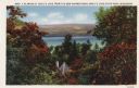
| Date: | 1933 |
|---|---|
| Description: | Colorized postcard of Devil's Lake and bluffs seen through the trees. Some of the trees have autumn color. A roof and chimney are visible. The text at the ... |

| Date: | 1914 |
|---|---|
| Description: | Colorized postcard of the rock formation called the Devil's Doorway in Devil's Lake State Park. Trees can be seen below. The lake, bluffs, roads and buildi... |

| Date: | 1923 |
|---|---|
| Description: | This topographical map of Devil's Lake State Park, Sauk County, Wisconsin, is based on 1922-1923 surveys of the area by the University of Wisconsin Summer ... |

| Date: | 02 1956 |
|---|---|
| Description: | This 1956 map of Waukesha County, Wisconsin, shows the township and range grid, towns, sections, cities and villages, roads, railroads, dams, airports, par... |
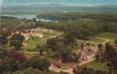
| Date: | |
|---|---|
| Description: | Color postcard of an elevated view of Stonefield Village with the Mississippi River in the background and railroad tracks in the foreground. |
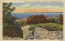
| Date: | 1939 |
|---|---|
| Description: | Caption reads: "High Cliff overlooking East Shore of Lake Winnebago, Wis." Elevated view of Lake Winnebago from High Cliff State Park. A stone outcropping ... |

| Date: | 1922 |
|---|---|
| Description: | Text on front reads: "Ann Mitchell Library-Tower Hill, Wis." A one-story, wooden building with a wrap-around veranda and broad front steps surrounded by tr... |
If you didn't find the material you searched for, our Library Reference Staff can help.
Call our reference desk at 608-264-6535 or email us at: