 Filter: Categories of Wisconsin Historical Images
Filter: FORMAT_TYPE of prints, photomechanical
Filter: Subject of state parks and reserves
Filter: Subject of outdoor photography
Filter: Categories of Wisconsin Historical Images
Filter: FORMAT_TYPE of prints, photomechanical
Filter: Subject of state parks and reserves
Filter: Subject of outdoor photography

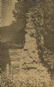
| Date: | 1954 |
|---|---|
| Description: | View looking west from Eagle Bluff toward Nicolet Bay, the Strawberry Islands, and Chambers Island. Three people are sitting on the stone wall of the overl... |
| Date: | 1960 |
|---|---|
| Description: | Cottage built by Marie Gatter beginning in the 1920s along the shore road in the park. It was razed in the winter of 1960-61. The chimney was originally pa... |
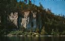
| Date: | 1960 |
|---|---|
| Description: | View across water towards the 180-foot high Eagle Bluff. The bluff received its name from the eagles which formerly nested there. |
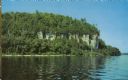
| Date: | 1960 |
|---|---|
| Description: | View across water towards the 180-foot high Eagle Bluff. The bluff received its name from the eagles which formerly nested there. |
| Date: | |
|---|---|
| Description: | Color postcard view of the rock formation called the Devil's Doorway in Devil's Lake State Park. Trees are changing color. The lake, bluffs and sky are in ... |

| Date: | 1956 |
|---|---|
| Description: | Color postcard view looking down at the rock formation called the Devil's Doorway in Devil's Lake State Park. The lake, bluffs and sky are in the backgroun... |

| Date: | 1965 |
|---|---|
| Description: | Color postcard view looking down at the rock formation called the Devil's Doorway in Devil's Lake State Park. The trees are changing color. The lake, bluff... |

| Date: | 1965 |
|---|---|
| Description: | Color postcard of the bathing beach at Devil's Lake State Park with a view of the East Bluff. The lake, bluffs and sky are in the background. Many visitor... |

| Date: | 1965 |
|---|---|
| Description: | Color postcard view of a rock formation above the lake in Devil's Lake State Park. The lake, bluffs, trees and sky are in the background. |

| Date: | 09 30 1969 |
|---|---|
| Description: | Color postcard of the view from the East Bluff looking towards Lake Wisconsin. The valley is filled with trees that are turning to autumn color. Some rock ... |

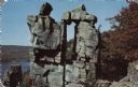
| Date: | 1965 |
|---|---|
| Description: | Color postcard view of the rock formation called Tomahawk Rock in Devil's Lake State Park. The lake and beach, trees, bluffs and sky are visible in the bac... |

| Date: | 1965 |
|---|---|
| Description: | Color postcard of the ramparts of the West Bluff in Devil's Lake State Park. Trees can be seen throughout and have fall color. The lake, bluffs and sky are... |

| Date: | 1965 |
|---|---|
| Description: | Color postcard of the lake viewed from the East Bluff Trail in Devil's Lake State Park. Trees can be seen all around and it is autumn. Rock formations are ... |

| Date: | |
|---|---|
| Description: | Black and white postcard of the boat landing in front of Cliff House, a resort hotel, in Devil's Lake State Park. Two men show off their catch of seven fis... |

| Date: | 09 24 1910 |
|---|---|
| Description: | View of several fisherman's homes on Bear Island, one of the islands that make up the Apostle Islands. An American flag is flying between buildings and a d... |
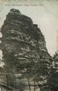
| Date: | 07 23 1912 |
|---|---|
| Description: | Colorized postcard of Devil's Monument with trees surrounding it. Text at top reads: "Devil's Monument, Camp Douglas, Wis." |

| Date: | 1975 |
|---|---|
| Description: | A tourist map of Grant County that displays the various activities and attractions found in the cities throughout the county, such as boat landings, fishin... |

| Date: | 1990 |
|---|---|
| Description: | This tourism brochure of Ashland County, Wisconsin, from the Ashland Area Chamber of Commerce includes a map of the county showing tourist destinations and... |

| Date: | 1991 |
|---|---|
| Description: | This 1991 map of Burnett County, Wisconsin, shows Governor Knowles State Forest, wildlife areas, public hunting grounds, and other outdoor recreation facil... |
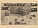
| Date: | 1893 |
|---|---|
| Description: | A bird’s-eye view map. Inset maps read: Honey Creek Basin and Baraboo Bluffs -- Sauk County -- The ancient Green Bay glacier. Includes distant chart, eleva... |
If you didn't find the material you searched for, our Library Reference Staff can help.
Call our reference desk at 608-264-6535 or email us at: