 Filter: Categories of Wisconsin Historical Images
Filter: FORMAT_TYPE of prints, photomechanical
Filter: Subject of storms
Filter: Categories of Wisconsin Historical Images
Filter: FORMAT_TYPE of prints, photomechanical
Filter: Subject of storms
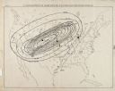
| Date: | 1871 |
|---|---|
| Description: | Weather map depicting the great cyclonic storm that prevailed the day of the Peshtigo and Chicago fires. |
| Date: | |
|---|---|
| Description: | Letterhead proof for the International Litho Artists and Engravers Insurance and Protective Association of the United States and Canada, of Milwaukee, Wisc... |

| Date: | 1868 |
|---|---|
| Description: | This map of the state of Wisconsin was created in 1868 and later used by Increase Lapham to trace an outbreak of tornadoes going across the state in May of... |

| Date: | 1868 |
|---|---|
| Description: | This map is one of the earliest weather maps of the United States, which traced an 1859 storm across the continent. Manuscript annotations in red ink show ... |
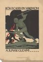
| Date: | 1918 |
|---|---|
| Description: | Poster featuring an illustration of a man with a musket and a handaxe charging at three fleeing soldiers, while red lightning flashes from dark storm cloud... |
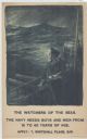
| Date: | 1915 |
|---|---|
| Description: | British poster with an illustration of a sailor holding a telescope under his left arm while standing on a the deck of a ship looking out at stormy seas to... |

| Date: | 07 18 1916 |
|---|---|
| Description: | Text on front reads: "Effect of Hard Storm, June 1st, 1916. Pra. Du Sac, Wis." Five adults and two children survey the damage after a large tree was blown ... |
If you didn't find the material you searched for, our Library Reference Staff can help.
Call our reference desk at 608-264-6535 or email us at: