Visit our other Wisconsin Historical Society websites!
 Filter: Categories of Wisconsin Historical Images
Filter: FORMAT_TYPE of prints, photomechanical
Filter: Subject of streets
Filter: Creator Name of Unknown
Filter: Categories of Wisconsin Historical Images
Filter: FORMAT_TYPE of prints, photomechanical
Filter: Subject of streets
Filter: Creator Name of Unknown
| Date: | 1900 |
|---|---|
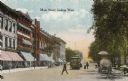
| Description: | View down Main Street on the Capitol Square. Caption reads: "Main Street, looking West." |

| Date: | 1884 |
|---|---|
| Description: | A sign for Fauerbach's Brewery depicting a young woman and the brewery. |
| Date: | 1910 |
|---|---|
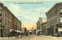
| Description: | Colorized view of King Street, looking east, with a streetcar. Lake Monona is in the background. Caption reads: "King Street, looking East, Madison, Wis." |
| Date: | |
|---|---|
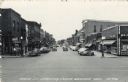
| Description: | View looking south down Main Street, which is lined with commercial business. Automobiles are parked at an angle on both sides of the street. Caption reads... |
| Date: | 1910 |
|---|---|
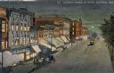
| Description: | Elevated view at night of streetcars moving along the Capitol Square on Pinckney Street. Walzinger's Drugstore is one of the prominent storefronts on the l... |
| Date: | 1915 |
|---|---|
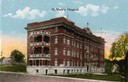
| Description: | St. Mary's Hospital soon after its completion in 1911. Caption reads: "St. Mary's Hospital." |
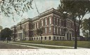
| Date: | 1915 |
|---|---|
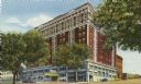
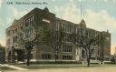
| Description: | Central High School, designed by St. Paul architect Cass Gilbert and partially razed in 1986. Caption reads: "High School, Madison, Wis." |

| Date: | 1836 |
|---|---|
| Description: | The top map is the "Plat of Madison the Capitol of Wisconsin." The bottom map is the "Map of the Four Lake Country. Taken from the Township Maps in the U.S... |

| Date: | 1889 |
|---|---|
| Description: | Illustration of the exterior of the Fuller Opera House, which is a detail from a bird's-eye view map of Madison. |

| Date: | 1881 |
|---|---|
| Description: | Bird's-eye map of Milton Junction. |

| Date: | 1879 |
|---|---|
| Description: | This map is a bird's-eye view of Wausau, the County Seat of Marathon County. The map features an index of points of interest. |
| Date: | 1908 |
|---|---|
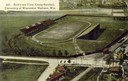
| Description: | Aerial view of Camp Randall Stadium on the University of Wisconsin-Madison campus. Top image on Place File card. Caption reads: "Bird's-eye View, Camp Ra... |
| Date: | 1909 |
|---|---|
| Description: | View of Main Street with streetcar. Caption reads: "Main Street, Madison, Wis." |
| Date: | 1905 |
|---|---|
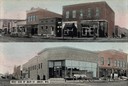
| Description: | Top view is from the intersection looking towards buildings on the right side of the street. The bottom view has a caption that reads: "West Side of Main S... |
| Date: | 1890 |
|---|---|
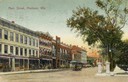
| Description: | View down College Avenue. Caption reads: "College Ave. looking East from Oneida St., Appleton, Wis." |
| Date: | 1907 |
|---|---|
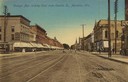
| Description: | View down College Avenue. Caption reads: "College Ave. looking West from Oneida St., Appleton, Wis." |
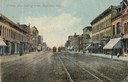
| Date: | 1910 |
|---|---|
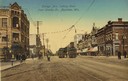
| Description: | View down College Avenue. Two streetcars are along tracks in the center of the street. Caption reads: "College Ave. looking West, Appleton, Wis." |
| Date: | 1905 |
|---|---|
| Description: | View from street towards the Appleton High School. Caption reads: "Appleton High School, Appleton, Wis." |
If you didn't find the material you searched for, our Library Reference Staff can help.
Call our reference desk at 608-264-6535 or email us at: