 Filter: Categories of Wisconsin Historical Images
Filter: FORMAT_TYPE of prints, photomechanical
Filter: Subject of streets
Filter: Community of Manitowoc
Filter: Categories of Wisconsin Historical Images
Filter: FORMAT_TYPE of prints, photomechanical
Filter: Subject of streets
Filter: Community of Manitowoc

| Date: | 1920 |
|---|---|
| Description: | View across street toward the library. Caption reads: "Public Library, Manitowoc, Wis." |

| Date: | 1907 |
|---|---|
| Description: | View up street with a large building on the corner on the right, and church buildings further down the street. Caption reads: "View up South Eigth Street f... |
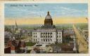
| Date: | 1925 |
|---|---|
| Description: | Elevated view of Manitowoc, dominated by the Manitowoc County Court House. Caption reads: "Bird's-eye View, Manitowoc, Wis." |

| Date: | |
|---|---|
| Description: | Letterhead of the William Rahr Sons' Company of Manitowoc, Wisconsin, "Maltsters and Roasters," with an elevated view of the company building on one side o... |

| Date: | 01 1899 |
|---|---|
| Description: | Shows lot and block numbers, railroads, ward boundaries, and some landownership. Includes public building index. |
| Date: | 1945 |
|---|---|
| Description: | Map features a legend with symbols of points of interest. The symbols are in red. The back of the map has text on "Points of Interest and Information". |

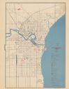
| Date: | 1905 |
|---|---|
| Description: | This map shows a plat of the city, local streets, railroads, public buildings, local businesses, and parts of the Manitowoc River and Lake Michigan. Relief... |

| Date: | |
|---|---|
| Description: | This plat map shows numbered blocks and lots, wards, local streets, railroads, cemeteries, buildings, land ownership by name, and parts of Manitowoc River ... |

| Date: | 1925 |
|---|---|
| Description: | This map shows a plat of the city, local streets, railroads, public buildings, local businesses, and parts of the Manitowoc River and Lake Michigan. Relief... |

| Date: | 1856 |
|---|---|
| Description: | This map shows the Manitowoc River, Lake Michigan, streets, and buildings. Relief is shown by hachures and soundings are in feet and decimals of a foot. Th... |

| Date: | 09 1853 |
|---|---|
| Description: | This map shows streets, docks, warehouses, and piers near the harbor. The Manitowoc River and Lake Michigan are labeled. Depths are indicated by soundings ... |

| Date: | 1854 |
|---|---|
| Description: | This map shows streets, docks, warehouses, and piers near the harbor. Relief is shown by hachures and depths are shown by soundings and isolines. Lake Mich... |

| Date: | 1856 |
|---|---|
| Description: | This map shows streets, piers, and wharves. Lake Michigan, the Manitowoc River, and select buildings are labeled. Relief is shown by hachures and sounding... |

| Date: | 1874 |
|---|---|
| Description: | This map shows piers, streets, the Manitowoc River and shore lines of 1856, 1869, 1873 and 1874. The top margin reads; "Soundings taken 1974." Written in i... |

| Date: | 1870 |
|---|---|
| Description: | This blueprint map shows lot and block numbers, streets, and right of way for the Two Rivers Branch railroad. The map covers land west to sections 22 and 2... |

| Date: | |
|---|---|
| Description: | Two views of Manitowoc. St. Boniface Catholic Church is at the top, and at the bottom is Washington Street. Caption at top reads: "St. Boniface Catholic Ch... |
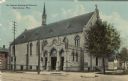
| Date: | 1912 |
|---|---|
| Description: | Three-quarter view from street towards a stone church. Streetcar tracks are running down the street. Caption reads: "St. James Episcopal Church, Manitowoc,... |
| Date: | |
|---|---|
| Description: | View of the O. Torrison building on the north bank of the Manitowoc River. Caption reads: "O. Torrison Co., Manitowoc, Wis." |
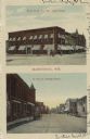
| Date: | |
|---|---|
| Description: | Two views: The one at the top is an exterior view of the B.P.O.E. No. 687 building. The view at the bottom is of N. 8th St. looking south. Caption at top r... |
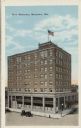
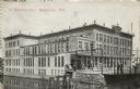
| Date: | 1934 |
|---|---|
| Description: | Elevated view of an eight-story hotel on a downtown corner. Automobiles are parked along the curb. Caption reads: "Hotel Manitowoc, Manitowoc, Wis." |
If you didn't find the material you searched for, our Library Reference Staff can help.
Call our reference desk at 608-264-6535 or email us at: