 Filter: Categories of Wisconsin Historical Images
Filter: FORMAT_TYPE of prints, photomechanical
Filter: Subject of streets
Filter: Community of Superior
Filter: Categories of Wisconsin Historical Images
Filter: FORMAT_TYPE of prints, photomechanical
Filter: Subject of streets
Filter: Community of Superior
| Date: | 1937 |
|---|---|
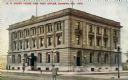
| Description: | Exterior view across street toward the Courthouse and Post Office. Caption reads: "U.S. Courthouse and Post Office, Superior, Wis." |
| Date: | 1909 |
|---|---|
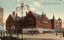
| Description: | View across street toward the Superior Hotel on a street corner. Caption reads: "Superior Hotel, Superior, Wis." |
| Date: | 1915 |
|---|---|
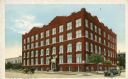
| Description: | Exterior view of the Young Men's Christian Association building on a street corner. Caption reads: "Y. M. C. A. Superior, Wis." |
| Date: | 1915 |
|---|---|
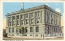
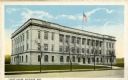
| Description: | Exterior view across street towards the Federal Building. Caption reads: "Federal Building, Superior, Wis." |
| Date: | 1915 |
|---|---|
| Description: | Exterior view of the Douglas County Courthouse. Caption reads: "Court House, Superior, Wis." |

| Date: | |
|---|---|
| Description: | Letterhead of the City of Superior, Wisconsin, with a three-quarter view of City Hall, printed in blue-green ink, with additional text in brown ink, by Typ... |

| Date: | 1890 |
|---|---|
| Description: | This map of Superior shows city wards, bays, docks, some businesses and points of interest. Relief is shown by hachures. The back of the map features a typ... |

| Date: | 1898 |
|---|---|
| Description: | This map of Superior shows city wards, bays, docks, and some businesses and points of interest. Relief is shown by hachures. The map probably came from a C... |

| Date: | 1898 |
|---|---|
| Description: | This map of Duluth and Superior show lands that "will be for sale soon" in portions of Douglas County, Wisconsin and Saint Louis County, Minnesota. The map... |

| Date: | 1951 |
|---|---|
| Description: | This map of Superior shows labeled streets, waterways, railroads, and company ownership of docks. |

| Date: | 1860 |
|---|---|
| Description: | This map of Superior is oriented with north to the upper left. Relief is shown by hachures and water depths are shown by soundings. Lake Superior and bays ... |

| Date: | 1863 |
|---|---|
| Description: | This map of Superior shows Montgomery's Addition. An inset map shows the south west end of Lake Superior where Montgomery's Addition is located. The map re... |

| Date: | 1887 |
|---|---|
| Description: | This map shows lot and block numbers, established dock lines, docks, slips, railroads, and streets of West Superior in 1887. |

| Date: | 1889 |
|---|---|
| Description: | This map shows lot and block numbers, established dock lines, docks, slips, railroads, and streets of West Superior in 1889. |

| Date: | 1890 |
|---|---|
| Description: | This map shows lot and block numbers, established dock lines, docks, slips, railroads, streets, selected industrial buildings, sites for manufactories, and... |

| Date: | 1891 |
|---|---|
| Description: | This colorful map shows additions, railroads, docks, streets, established dock lines, marshes, and proposed belt line railroad. The map covers west and sou... |

| Date: | 1894 |
|---|---|
| Description: | This map shows lot and block numbers, railroads, street car tracks, sewers, water mains, gas mains, paved streets, land owned by the Land & River Improveme... |

| Date: | 1898 |
|---|---|
| Description: | This map shows blocks, industrial buildings, and railroads in portions of Duluth and Superior, as well as harbor lines, areas improved, and proposed improv... |

| Date: | 1914 |
|---|---|
| Description: | This map shows streets, industrial buildings, a portion of Lake Superior and other lakes, bays, and rivers in portions of Duluth and Superior. Relief is sh... |

| Date: | 1940 |
|---|---|
| Description: | This ward map shows streets, the Nemadji River, and addition and division boundaries. Also included is a list of members of the Douglas County Board town, ... |
If you didn't find the material you searched for, our Library Reference Staff can help.
Call our reference desk at 608-264-6535 or email us at: