 Filter: Categories of Wisconsin Historical Images
Filter: FORMAT_TYPE of prints, photomechanical
Filter: Subject of streets
Filter: Subject of boats and boating
Filter: Categories of Wisconsin Historical Images
Filter: FORMAT_TYPE of prints, photomechanical
Filter: Subject of streets
Filter: Subject of boats and boating

| Date: | 1870 |
|---|---|
| Description: | This bird's-eye-view map shows roads, a river with boats, and homes. The bottom margin of the map includes an index. |

| Date: | 1898 |
|---|---|
| Description: | Bird's-eye map of Milwaukee with prominent streets and buildings identified. Taken from City Hall Tower. |

| Date: | 1877 |
|---|---|
| Description: | Bird's-eye map of Janesville on the Rock River. |

| Date: | 1874 |
|---|---|
| Description: | Bird's-eye view of Waukesha, looking southwest, with insets of State Industrial School, Court House, and Fountain Spring House. |

| Date: | 1870 |
|---|---|
| Description: | Bird's-eye view of Whitewater, with insets. |

| Date: | 1949 |
|---|---|
| Description: | Color bird's-eye map of the University of Wisconsin-Madison as it was midcentury, with two co-eds, several photographs of campus landmarks around edges, an... |
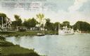
| Date: | 1908 |
|---|---|
| Description: | View from shoreline towards a large boat, perhaps an excursion boat, and sailboats docked further down along the curving shoreline. Beyond the boats is a t... |

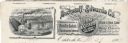
| Date: | |
|---|---|
| Description: | Letterhead of the Phillip Best Brewing Company of Milwaukee, Wisconsin, with three separate proscenium views of the Empire Brewery, the South Side Brewery,... |
| Date: | |
|---|---|
| Description: | Memohead of the Buckstaff-Edwards Company of Oshkosh, Wisconsin, manufacturers of coffins and caskets and wholesale dealers in caskets and undertaking supp... |

| Date: | |
|---|---|
| Description: | Letterhead of the William Rahr Sons' Company of Manitowoc, Wisconsin, "Maltsters and Roasters," with an elevated view of the company building on one side o... |

| Date: | 1928 |
|---|---|
| Description: | Illustrated map of points of interest, including University buildings, parks, athletic venues, fraternity and sorority houses, and state buildings. |

| Date: | 1914 |
|---|---|
| Description: | This map shows streets, industrial buildings, a portion of Lake Superior and other lakes, bays, and rivers in portions of Duluth and Superior. Relief is sh... |

| Date: | 1882 |
|---|---|
| Description: | This pictorial bird's-eye-view map shows buildings, streets, and railroads. Included are illustrations and an index to points of interest. The bottom of th... |

| Date: | 1908 |
|---|---|
| Description: | This map shows streets, industrial buildings, a portion of Lake Superior and other lakes, bays, and rivers in portions of Duluth and Superior. Relief is sh... |

| Date: | 1986 |
|---|---|
| Description: | Pictorial map showing businesses with phone numbers, roads, railroads, and parks. Includes text titled: "History of Portage County." |

| Date: | 06 25 1901 |
|---|---|
| Description: | This map shows beacons, buoys, docks, quarries, streets, and buildings. The map inset shows the Harbor of refuge at entrance to Sturgeon Bay and Lake Michi... |

| Date: | 12 28 1908 |
|---|---|
| Description: | This map shows beacons, buildings, streets, and quarries. Two inset maps include: Vicinity of Sturgeon Bay, Wis. and the Harbor of refuge at entrance to St... |

| Date: | 1905 |
|---|---|
| Description: | This map shows a plat of the city, local streets, railroads, public buildings, local businesses, and parts of the Manitowoc River and Lake Michigan. Relief... |
If you didn't find the material you searched for, our Library Reference Staff can help.
Call our reference desk at 608-264-6535 or email us at:

