 Filter: Categories of Wisconsin Historical Images
Filter: FORMAT_TYPE of prints, photomechanical
Filter: Subject of streets
Filter: Subject of buildings
Filter: Categories of Wisconsin Historical Images
Filter: FORMAT_TYPE of prints, photomechanical
Filter: Subject of streets
Filter: Subject of buildings

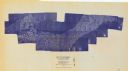
| Date: | 1950 |
|---|---|
| Description: | Map showing buildings formerly used as Ringling Brothers Circus winter quarters, along with adjoining buildings. |
| Date: | 1910 |
|---|---|
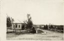
| Description: | Street scene in Ellison Bay. On the far left is a building with a bell tower on the roof. Caption reads: "St. Scene, Ellison Bay, Wis." |
| Date: | 1885 |
|---|---|
| Description: | Burton House, (also referred to as the Ridge House by Edna Ferber in her novel, "Come and Get It") with horse-drawn carriages in the foreground. |

| Date: | 1920 |
|---|---|
| Description: | Exterior view of the opera house and the Eagle's Hall. Caption reads: "Opera House, Sheboygan, Wis. Eagles Hall." |
| Date: | |
|---|---|
| Description: | View across street towards a red brick building with a flag pole in the yard on the left. A small stone block that reads "Calumet" is on the sidewalk. Capt... |

| Date: | 1905 |
|---|---|
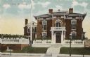
| Description: | View across street toward the Young Men's Christian Association building (YMCA). Caption reads: "Y. M. C. A., Milwaukee, Wis." |

| Date: | 1891 |
|---|---|
| Description: | This maps has an index of depots, hotels, prominent institutions and buildings, churches, and places of amusement. The map was removed from an unidentified... |

| Date: | 1929 |
|---|---|
| Description: | This map is oriented with north to the upper right. Includes index of retailers and buildings, with some advertisements in margins. |
| Date: | |
|---|---|
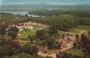
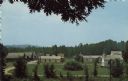
| Description: | Color postcard of an elevated view of Stonefield Village with the Mississippi River in the background and railroad tracks in the foreground. |
| Date: | |
|---|---|
| Description: | Elevated color postcard view of Stonefield Village from across the churchyard. |
| Date: | 1973 |
|---|---|
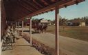
| Description: | Color postcard of Main Street from porch on building at Stonefield Village. A horse bus with tourists is in the street. |

| Date: | 1871 |
|---|---|
| Description: | This map of Waukesha shows lot owners, buildings, and various plat additions. The margins of the maps include street reference, a Waukesha business directo... |
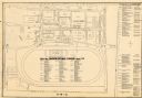
| Date: | 1948 |
|---|---|
| Description: | This map of the Wisconsin Centennial Exposition is oriented with north to the right. The right hand margin includes "Outstanding Events of the Grandstand P... |

| Date: | 1967 |
|---|---|
| Description: | This map of Cedarburg includes a list of historic buildings in the left margin. The map was created by the Ozaukee County Historical Society for Cedarburg'... |

| Date: | 1889 |
|---|---|
| Description: | This map shows a plat of city, city limits, numbered blocks, numbered lots, wards, local streets, roads, railroads, street railways, fire limits, hydrants,... |

| Date: | 1938 |
|---|---|
| Description: | This map shows buildings, lots, parks, schools, pumping stations, sites reserved for churches, and water towers. |

| Date: | 1856 |
|---|---|
| Description: | This map is ink and watercolor on tracing paper and shows plat of city, local streets, block numbers, topography, several buildings, and includes an explan... |

| Date: | 1882 |
|---|---|
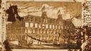
| Description: | This pictorial bird's-eye-view map shows buildings, streets, and railroads. Included are illustrations and an index to points of interest. The bottom of th... |

| Date: | 1857 |
|---|---|
| Description: | This map shows land ownership by name, local streets, wards, buildings, parks, a cemetery, and part of Lake Michigan. Depths are shown by soundings and nor... |
| Date: | 1975 |
|---|---|
| Description: | This bird’s-eye-view map is a series of photographs compiled to show local streets and buildings. |
If you didn't find the material you searched for, our Library Reference Staff can help.
Call our reference desk at 608-264-6535 or email us at: