 Filter: Categories of Wisconsin Historical Images
Filter: FORMAT_TYPE of prints, photomechanical
Filter: Subject of streets
Filter: Subject of college buildings
Filter: Categories of Wisconsin Historical Images
Filter: FORMAT_TYPE of prints, photomechanical
Filter: Subject of streets
Filter: Subject of college buildings

| Date: | 1949 |
|---|---|
| Description: | Color bird's-eye map of the University of Wisconsin-Madison as it was midcentury, with two co-eds, several photographs of campus landmarks around edges, an... |
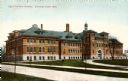
| Date: | 1905 |
|---|---|
| Description: | Exterior view of the State Normal College. Caption reads: "State Normal School, Stevens Point, Wis." |

| Date: | 1913 |
|---|---|
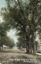
| Description: | View down tree-lined Langdon Street and the lower campus of the University of Wisconsin. Caption reads: "Langdon Street through lower campus, University of... |
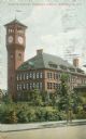
| Date: | 1905 |
|---|---|
| Description: | Stout State College Bowman Building with clock tower. It is attached to the central school building by a second-story bridge. Caption reads: "Stous Manual ... |
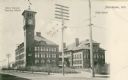
| Date: | 1912 |
|---|---|
| Description: | View across street towards the Stout Manual Training School on the left, and the high school on the right. Captions read: "Stout Manual Training School," "... |
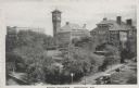
| Date: | |
|---|---|
| Description: | Elevated view of school buildings in Menomonie, later a part of the Stout State College. The building in the center has a clock tower. Caption reads: "Scho... |
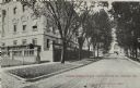
| Date: | 1905 |
|---|---|
| Description: | Parker [sic] Street, looking toward Lake Mendota. A portion of the Wisconsin Historical Society building is on the right. Caption reads: "Parker St. from U... |
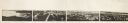
| Date: | 1870 |
|---|---|
| Description: | Panoramic view of Madison, taken from the roof of South Hall. This reduced copy was made from original negatives by E.C. Nielson. Labels for both Lake Mend... |

| Date: | |
|---|---|
| Description: | Black and white postcard of the Upper Campus, the west side of the State Historical Library, now the headquarters building of the Wisconsin Historical Soci... |
| Date: | |
|---|---|
| Description: | Black and white postcard of the north end of the State Historical Library, now the headquarters building of the Wisconsin Historical Society, and Langdon S... |
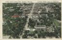
| Date: | |
|---|---|
| Description: | Aerial view of College Avenue looking west. Several campus buildings at Lawrence College are in the foreground. Caption reads: "College Avenue looking West... |

| Date: | 1929 |
|---|---|
| Description: | Shows fraternities, sororities, major rooming houses, private and university buildings, and university property. Oriented with north slightly to the right. |

| Date: | 1950 |
|---|---|
| Description: | Includes building index and "To Help You Locate Buildings" text. Index includes campus buildings and points of interest. Aerial view on verso. |

| Date: | 1976 |
|---|---|
| Description: | Indexed map of campus buildings, streets, and residence halls. Also included on the map is information about buses. The back of the map features campus bus... |

| Date: | 1889 |
|---|---|
| Description: | This map shows a plat of city, city limits, numbered blocks, numbered lots, wards, local streets, roads, railroads, street railways, fire limits, hydrants,... |

| Date: | 1902 |
|---|---|
| Description: | Madison Sanborn map, including Langdon and State Streets. |

| Date: | 1908 |
|---|---|
| Description: | A detail of a Madison Sanborn map that includes the University of Wisconsin Boat House, UW Gymnasium & Armory (The Red Gym), fraternity houses, and the YMC... |

| Date: | 1920 |
|---|---|
| Description: | This blue print map and blue line print copy mounted on cloth shows land ownership by name, campus buildings, local streets, railroads, and part of Lake Me... |
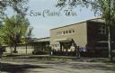
| Date: | 1965 |
|---|---|
| Description: | Photographic postcard view from street towards the Wisconsin State College in Eau Claire. Students are on the sidewalk. Caption reads: "Eau Claire, Wis." |
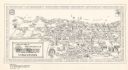
| Date: | 1972 |
|---|---|
| Description: | This bird’s-eye-view map shows campus buildings labeled by name or academic department, local streets, and part of Lake Mendota. Relief is shown pictorial... |
If you didn't find the material you searched for, our Library Reference Staff can help.
Call our reference desk at 608-264-6535 or email us at: