 Filter: Categories of Wisconsin Historical Images
Filter: FORMAT_TYPE of prints, photomechanical
Filter: Subject of streets
Filter: Subject of land
Filter: Categories of Wisconsin Historical Images
Filter: FORMAT_TYPE of prints, photomechanical
Filter: Subject of streets
Filter: Subject of land

| Date: | 09 1871 |
|---|---|
| Description: | Bird's-eye view of Peshtigo, before it was destroyed by fire on the night of October 8, 1871. |

| Date: | 1881 |
|---|---|
| Description: | Bird's-eye map of Marinette, with insets. |

| Date: | 1908 |
|---|---|
| Description: | Colored map showing a panoramic view of Madison in great detail. The Wisconsin State Capitol is located at the center, with Lake Mendota in the background ... |

| Date: | 1890 |
|---|---|
| Description: | Bird's-eye map of Ashland, viewed from Lake Superior, with insets of Prentice Park and Fishery. Population 16,000. Increase in Ten Years, 11,000. |

| Date: | 1836 |
|---|---|
| Description: | The top map is the "Plat of Madison the Capitol of Wisconsin." The bottom map is the "Map of the Four Lake Country. Taken from the Township Maps in the U.S... |

| Date: | 1878 |
|---|---|
| Description: | Bird's-eye map of Chilton with insets of points of interest, including P.H. Becker's Brewery, Chilton House, and Gutheil's Block. |

| Date: | 1877 |
|---|---|
| Description: | Bird's-eye map of Janesville on the Rock River. |

| Date: | 1910 |
|---|---|
| Description: | Bird's-eye view looking east, with Washburn Harbor at center and Chequamegon Bay in Lake Superior covering most of the upper image. Streets with buildings... |

| Date: | 1879 |
|---|---|
| Description: | This map is a bird's-eye view of Wausau, the County Seat of Marathon County. The map features an index of points of interest. |

| Date: | 1855 |
|---|---|
| Description: | Part of George Harrison's "Map of the City of Madison," showing the development of the isthmus and the small size of the second Capitol (54' x 104') in com... |

| Date: | 1896 |
|---|---|
| Description: | A portion of John B. Heim's map of the Water Works System of Madison showing the size of the third Wisconsin Capitol (228' x 226') in comparison with the C... |

| Date: | 1892 |
|---|---|
| Description: | Bird's-eye view of Chicago, with ships in the Lake Michigan harbor. |
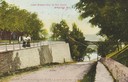
| Date: | |
|---|---|
| Description: | Scenic view of two women standing along a railing on a sidewalk above a stone wall viewing the way to the river. Caption reads: "Lawe Street Hill to Fox Ri... |
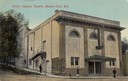
| Date: | 1912 |
|---|---|
| Description: | Exterior view of the Davison Theater. Caption reads: "Davison Theatre, Beaver Dam, Wis." |
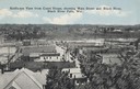
| Date: | 1915 |
|---|---|
| Description: | Elevated view from the Court House. Hills are in the distance. Caption reads: "Bird's-eye View from Court House, showing Main Street and Black River, Black... |
| Date: | 1905 |
|---|---|
| Description: | View down street towards Soldiers' Monument. Caption reads: "Soldiers' Monument, Darlington, Wis." |
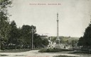
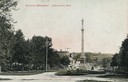
| Date: | 1907 |
|---|---|
| Description: | View down road looking towards Soldiers' Monument and town beyond. Caption reads: "Soldiers' Monument, Darlington, Wis." |
| Date: | 1900 |
|---|---|
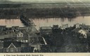
| Description: | Elevated view of Durand. A street in the foreground leads to a bridge that crosses the river. Caption reads: "A View from Morsbach Bluff, Durand, Wis." |
If you didn't find the material you searched for, our Library Reference Staff can help.
Call our reference desk at 608-264-6535 or email us at:

