 Filter: Categories of Wisconsin Historical Images
Filter: FORMAT_TYPE of prints, photomechanical
Filter: Subject of streets
Filter: Subject of learning and scholarship
Filter: Categories of Wisconsin Historical Images
Filter: FORMAT_TYPE of prints, photomechanical
Filter: Subject of streets
Filter: Subject of learning and scholarship

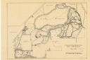
| Date: | 1874 |
|---|---|
| Description: | Bird's-eye map of Racine, with an inset of Racine College. |
| Date: | 1905 |
|---|---|
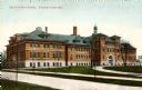
| Description: | Exterior view of the State Normal College. Caption reads: "State Normal School, Stevens Point, Wis." |

| Date: | 1913 |
|---|---|
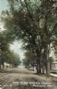
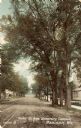
| Description: | View down tree-lined Langdon Street and the lower campus of the University of Wisconsin. Caption reads: "Langdon Street through lower campus, University of... |

| Date: | |
|---|---|
| Description: | Plat map of the east central part of the city. |
| Date: | 1905 |
|---|---|
| Description: | Parker [sic] Street, looking toward Lake Mendota. A portion of the Wisconsin Historical Society building is on the right. Caption reads: "Parker St. from U... |

| Date: | 1910 |
|---|---|
| Description: | View of Saint Paul's University Chapel at 723 State Street. Caption reads: "St. Paul's University Chapel, Madison, Wis." |
| Date: | |
|---|---|
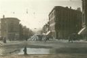
| Description: | View of State Street from the Wisconsin State Capitol grounds, looking west toward Bascom Hill. |

| Date: | 1920 |
|---|---|
| Description: | Elevated view looking west from the Wisconsin State Capitol dome. Caption reads: "Looking West from Capitol Dome, Madison, Wis." |

| Date: | |
|---|---|
| Description: | Colorized postcard of an exterior view of the State Historical Library, now the headquarters building of the Wisconsin Historical Society. Text at top read... |

| Date: | |
|---|---|
| Description: | Black and white postcard of the Upper Campus, the west side of the State Historical Library, now the headquarters building of the Wisconsin Historical Soci... |
| Date: | 09 14 1912 |
|---|---|
| Description: | Colorized postcard of Park[er] Street and the West End of the State Historical Library, now the headquarters building of the Wisconsin Historical Society. ... |

| Date: | 1860 |
|---|---|
| Description: | This map of Dodge County, Wisconsin, shows the township and range grid, towns, sections, cities and villages, railroads, roads, property owners and acreage... |

| Date: | 1928 |
|---|---|
| Description: | Illustrated map of points of interest, including University buildings, parks, athletic venues, fraternity and sorority houses, and state buildings. |
| Date: | 05 1938 |
|---|---|
| Description: | Map of the University of Wisconsin-Madison arboretum and wild life refuge. Roads are labelled, left to right: "Nakoma Road," "Monroe St.," "Manitou Way," "... |

| Date: | 1918 |
|---|---|
| Description: | This map shows Madison and includes an index of University of Wisconsin buildings, city buildings, and churches. Lake Mendota, Lake Monona, and Lake Wingra... |

| Date: | 1871 |
|---|---|
| Description: | This map shows buildings, roads, the railroad, an orchard, and swamp land. Relief shown by hachures. The map includes an index of buildings in the upper ri... |

| Date: | 1855 |
|---|---|
| Description: | This map shows a plat of the city, local streets, numbered blocks and lots, university grounds, the Capitol Square, and parts of Third and Fourth Lakes (La... |

| Date: | 1873 |
|---|---|
| Description: | This map shows land ownership by name, local streets, railroads, parks, college grounds, schools, cemeteries, and part of Rock River. The upper left margin... |

| Date: | 1929 |
|---|---|
| Description: | This is a blue line print map that shows local streets, railroads, local businesses, schools, parks, cemeteries, the airport, the state capitol, the Univer... |

| Date: | 1932 |
|---|---|
| Description: | This map shows local streets, section lines, Nakoma Country Club, part of Lake Forest, and part of Lake Wingra. The map includes a legend showing areas of ... |
If you didn't find the material you searched for, our Library Reference Staff can help.
Call our reference desk at 608-264-6535 or email us at: