 Filter: Categories of Wisconsin Historical Images
Filter: FORMAT_TYPE of prints, photomechanical
Filter: Subject of streets
Filter: Subject of recreation
Filter: Categories of Wisconsin Historical Images
Filter: FORMAT_TYPE of prints, photomechanical
Filter: Subject of streets
Filter: Subject of recreation

| Date: | 1870 |
|---|---|
| Description: | Bird's-eye view of Whitewater, with insets. |

| Date: | 1949 |
|---|---|
| Description: | Color bird's-eye map of the University of Wisconsin-Madison as it was midcentury, with two co-eds, several photographs of campus landmarks around edges, an... |
| Date: | 1908 |
|---|---|
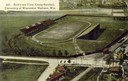
| Description: | Aerial view of Camp Randall Stadium on the University of Wisconsin-Madison campus. Top image on Place File card. Caption reads: "Bird's-eye View, Camp Ra... |

| Date: | 1950 |
|---|---|
| Description: | Map showing buildings formerly used as Ringling Brothers Circus winter quarters, along with adjoining buildings. |
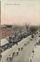
| Date: | 1910 |
|---|---|
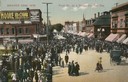
| Description: | Crowds on Front Street during Dodge County Fair day, circa 1910-1915. Caption reads: "Front St., on a Dodge Co. Fair Day." |
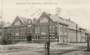
| Date: | 1930 |
|---|---|
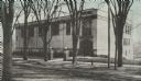
| Description: | View across street towards the gymnasium for the State Normal School. |

| Date: | 1920 |
|---|---|
| Description: | Map of the Nakoma neighborhood including the proposed golf grounds. |

| Date: | 1873 |
|---|---|
| Description: | Slightly elevated engraved view of the Walworth County Courthouse. In the foreground a man is riding a horse along the street. Pedestrians are on the groun... |
| Date: | 1905 |
|---|---|
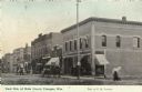
| Description: | View of the east side of Main Street, featuring a book and stationery store and a pool hall. Caption reads: "East Side of Main Street, Viroqua, Wis." |

| Date: | 1905 |
|---|---|
| Description: | Elevated view of State Street. There is a parade coming down the street, and crowds are on the sidewalks. Caption reads: "State Street, Looking East, Maust... |
| Date: | 11 02 1912 |
|---|---|
| Description: | View across unpaved road towards the gymnasium and natatorium. Caption reads: "Gymnasium and Natatorium, Menominee, Wis." |

| Date: | 1936 |
|---|---|
| Description: | Five people sitting on a sidewalk outside of a building. A woman stands on a stoop in the doorway. |

| Date: | 1970 |
|---|---|
| Description: | A map of parks of Kewaunee County, Wisconsin, showing the fishing spots, lakes and parks in the area, it also provides a location map of the area. On the ... |

| Date: | 1968 |
|---|---|
| Description: | A tourist map of Milwaukee County and of downtown Milwaukee. The Map of Milwaukee County identifies the location of some of the points of interests in the ... |

| Date: | 1928 |
|---|---|
| Description: | Illustrated map of points of interest, including University buildings, parks, athletic venues, fraternity and sorority houses, and state buildings. |

| Date: | 1950 |
|---|---|
| Description: | Includes building index and "To Help You Locate Buildings" text. Index includes campus buildings and points of interest. Aerial view on verso. |

| Date: | 1990 |
|---|---|
| Description: | Map of bike routes in Madison. Lower right corner features a system map with legend. Upper left corner is an inset of the Capital Loop with labelled points... |

| Date: | 1927 |
|---|---|
| Description: | Map reads: "Now You Can Visualize Madison". Includes indexes, with points marked 1-98 and a key. Text and illustrations on verso include hotels and seasona... |
| Date: | 1910 |
|---|---|
| Description: | Colorized postcard of an elevated view of a parade going through the central business district. People in the parade are wearing helmets and riding horseba... |

| Date: | 1932 |
|---|---|
| Description: | This map of Granville shows streets, businesses, residential areas, schools, golf courses, and industrial areas. The map shows Granville in March of 1932. ... |
If you didn't find the material you searched for, our Library Reference Staff can help.
Call our reference desk at 608-264-6535 or email us at: