 Filter: Categories of Wisconsin Historical Images
Filter: FORMAT_TYPE of prints, photomechanical
Filter: Subject of streets
Filter: Subject of tourism
Filter: Categories of Wisconsin Historical Images
Filter: FORMAT_TYPE of prints, photomechanical
Filter: Subject of streets
Filter: Subject of tourism

| Date: | 1970 |
|---|---|
| Description: | A map of parks of Kewaunee County, Wisconsin, showing the fishing spots, lakes and parks in the area, it also provides a location map of the area. On the ... |

| Date: | 1976 |
|---|---|
| Description: | A street map of Milwaukee County, Wisconsin that identifies the location of schools, hospitals, parks, beaches, streets, freeways, both planned or under co... |

| Date: | 1976 |
|---|---|
| Description: | This 1976 map of Washington County, Wisconsin, shows towns, cities and villages, highways and roads, existing and proposed county trails, and various publi... |

| Date: | 1927 |
|---|---|
| Description: | Map reads: "Now You Can Visualize Madison". Includes indexes, with points marked 1-98 and a key. Text and illustrations on verso include hotels and seasona... |
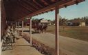
| Date: | 1973 |
|---|---|
| Description: | Color postcard of Main Street from porch on building at Stonefield Village. A horse bus with tourists is in the street. |

| Date: | 1900 |
|---|---|
| Description: | This map of Three Lakes shows forest fire lookout towers, picnic grounds, an airport, roads, and railroad. The map features text boxes on the Village of Th... |

| Date: | 1956 |
|---|---|
| Description: | This map of Racine includes a street directory and index of public buildings. Streets, points of interest, Lake Michigan, and the Root River are labeled. A... |

| Date: | 1956 |
|---|---|
| Description: | This map is intended for tourists of La Crosse. The front of the map is text about attractions, activities, and accommodations in La Crosse. The back is th... |

| Date: | 1970 |
|---|---|
| Description: | This map is intended for tourists of La Crosse. The cover features images of farms and natural land and reads: "friends are but strangers... we have yet to... |

| Date: | 1959 |
|---|---|
| Description: | This map of Lake Geneva has relief shown by contours and water depths shown by isolines. The map includes an index of schools, churches, public services, i... |

| Date: | 1956 |
|---|---|
| Description: | Intended for tourists, this brochure features a map of Milwaukee's central business district as well as general information about parking, beaches and othe... |

| Date: | 1924 |
|---|---|
| Description: | Intended for tourists, this brochure, titled: "Plan Now to See Madison, The Four Lake City: "The City Built on an Isthmus," features a map of Madison and s... |

| Date: | 1987 |
|---|---|
| Description: | This pictorial map shows roads, bridges, local businesses with phone numbers, and public buildings. Relief is shown pictorially. Also included is a calen... |

| Date: | 1989 |
|---|---|
| Description: | This pictorial map shows the Sheboygan river, businesses with phone numbers, historical buildings, other places of interest, and includes a brief history o... |

| Date: | 1986 |
|---|---|
| Description: | Pictorial map showing businesses with phone numbers, roads, railroads, and parks. Includes text titled: "History of Portage County." |

| Date: | 1989 |
|---|---|
| Description: | This pictorial map shows Lake Michigan, businesses with phone numbers, schools, parks, other points of interest, and includes a brief history of the town. ... |

| Date: | 1942 |
|---|---|
| Description: | This map shows the route of the Milwaukee Road, roads, foot trails, resorts, and ranger stations. The map includes text, illustrations, a railroad fare tab... |

| Date: | 1990 |
|---|---|
| Description: | This map shows the Minnesota Point, Wisconsin Point, Hog Island, Baker's Island, Connors Point, Blatnik Bridge, Superior Bay, Allouez Bay, the Nemadji Rive... |

| Date: | 2008 |
|---|---|
| Description: | This double sided map shows roads, railroads, biking trails, civil townships, parks, wildlife refuges, town halls, and hospitals. The region map covers par... |
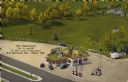
| Date: | 07 21 1949 |
|---|---|
| Description: | Text on the front reads: "The Highlands, Hy. 41 and 20, 21 miles south of Milwaukee, P.O. Sturtevant, Wis. - Phone: 18W." Additional text on the reverse: "... |
If you didn't find the material you searched for, our Library Reference Staff can help.
Call our reference desk at 608-264-6535 or email us at: