 Filter: Categories of Wisconsin Historical Images
Filter: FORMAT_TYPE of prints, photomechanical
Filter: Subject of tourism
Filter: County of Sauk
Filter: Categories of Wisconsin Historical Images
Filter: FORMAT_TYPE of prints, photomechanical
Filter: Subject of tourism
Filter: County of Sauk

| Date: | 1915 |
|---|---|
| Description: | This 1915 map covers the section of the Wisconsin River in southern Adams, southeastern Juneau, northeastern Sauk, and northwestern Columbia counties. A po... |
| Date: | |
|---|---|
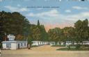
| Description: | Colorized postcard view of the exterior view of a motel. A neon sign over the main building. A gas pump is in the drive. Caption reads: "Devi-Dells Cabins,... |
| Date: | 1914 |
|---|---|
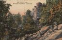
| Description: | Castle Rock at Devil's Lake, number 4801 in E.A. Bishop's Wisconsin State Park Series. Caption on back of postcard reads: "Our State Parks now rank among t... |
| Date: | 1910 |
|---|---|
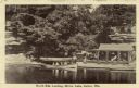
| Description: | View across water towards the North Side Landing. There is a covered tour boat at the edge of the lake and passengers on board. At the shoreline is a cabin... |

| Date: | 1940 |
|---|---|
| Description: | This pictorial map shows points of interest, recreation activities, and highways in the vicinity of the restaurant and covers the Wisconsin River Valley be... |
| Date: | 1963 |
|---|---|
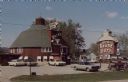
| Description: | Text on reverse reads: "Rock's Round Barn on Highway U.S. 14 near Spring Green, Wisconsin, is a very unique restaurant featuring a new and novel 'salad bar... |
| Date: | 1950 |
|---|---|
| Description: | Text on the reverse reads: "The House on the Rock, at Spring Green, Wisconsin, on Highway 23, North of Dodgeville, Wisconsin. Access to this rock is throug... |

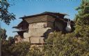
| Date: | 07 25 1995 |
|---|---|
| Description: | Text on the reverse reads: "The House on the Rock. Spring Green, Wisconsin 53588. The House on the Rock comes alive with spectacular autumn colors. This ar... |
If you didn't find the material you searched for, our Library Reference Staff can help.
Call our reference desk at 608-264-6535 or email us at: